


DENVER – The National Weather Service in Boulder published an analysis Wednesday of the meteorological and climatological factors that helped turn the Marshall Fire into what officials have called a “firestorm” and burn through hundreds of homes and businesses in Boulder County.
The analysis details the host of factors – including winds that were gusting 80 to 100 miles per hour, extreme drought conditions, and a mountain wave – that caused the fire to burn more than 6,000 acres in a matter of hours.
The fire started shortly after 11 a.m. on Dec. 30 near Colorado Highway 93 and Eldorado Springs Drive in Boulder County, according to archived dispatch recordings. Those same recordings show it was spreading quickly toward homes in the area over the next half hour.

At 11 a.m. that day, winds in south Boulder were gusting to 81 miles per hour and up to 99 miles per hour at the intersection of Highway 93 and Highway 72 south of where the fire started, according to the NWS.
The first mandatory evacuation order was issued at 11:47 a.m. to people living in the area between Highway 93, Marshall Road and Cherryvale Road.

By noon, winds had increased – with an 85-mph gust recorded in south Boulder and a 115-mph gust recorded just east of the intersections of Highways 93 and 72.
MORE: Officials analyze Marshall Fire emergency response and concerns regarding evacuation notices
Another mandatory evacuation order was issued at 12:15 p.m. to people on both sides of Marshall Road between S. 76th Street and McCaslin Boulevard. By that point, nearly 3,000 homeowners in the area had been alerted to evacuate, though not all residents were opted in to the county’s emergency alert system.
Between noon and 2 p.m., the high winds shifted slightly east, according to the NWS, and into Superior and most of Louisville – pushing the fire eastward along with it. Over that time period, mandatory evacuation orders and evacuation warnings were issued for all of Superior, south Louisville and much of the area that eventually burned, according to the Boulder County Office of Disaster Management.
At 2 p.m., a 68-mph gust was recorded near the Coal Creek Golf Course where hundreds of homes were destroyed. The NWS said the fire was spreading quickly through Louisville by that point after burning through most of Superior.
Because of the topography just west of Superior, where the foothills and mountains begin, a mountain wave was created that day as the downslope winds blew down the mountains and hit the plains. Superior and Louisville were located just underneath the “jump region” where the winds weakened and lifted. The NWS said there were also easterly winds at times in the area just east of Louisville that created a “rotor” of wind just below the jump region. (Click here for more visuals of the mountain wave from the NWS.)

“It takes just the right combination of meteorological parameters, including stability, wind shear, and wind magnitude to create a powerful and damaging windstorm like this one,” the NWS wrote in its analysis.
The final mandatory evacuation order that was issued that day for the fire was sent to 4,806 contacts north of Cherry Street and Bella Vista Drive, east of McCaslin Boulevard and Via Appia Way, and west of Courtesy Road in Louisville at 2:51 p.m. Several homes were destroyed in the western part of this evacuation zone as well.
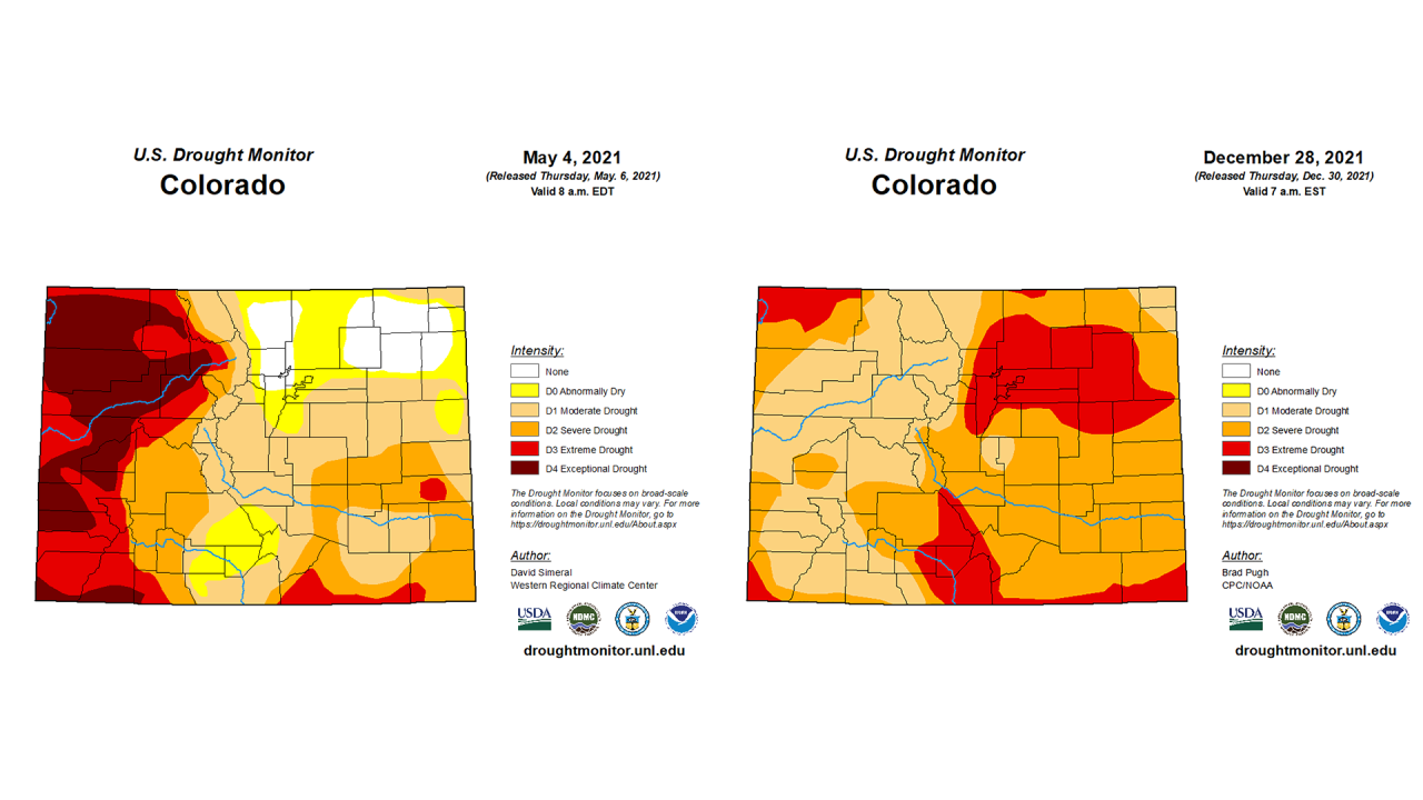
In addition to the hurricane force winds, the area in Boulder County that burned in the Marshall Fire was experiencing extreme drought conditions at the time, according to the U.S. Drought Monitor.
But spring snow and rain had brought southern Boulder County out of all drought conditions in early May. The area was drought-free until the end of August. But the moisture at the beginning of the year led grasses to grow long over the spring and summer before it started to dry out in July, when the moisture left the area for most of the rest of 2021.
The period between July 1 and Dec. 29 – a day before the fire – was the second warmest ever over that time period in the Denver area, with an average temperature of 60.3 degrees. And it was by far the driest year over that period on record, as only 1.08 inches of precipitation fell. The second-driest year on record over that period was 1962, but a full 1.01 more inches of precipitation fell that year for a total of 2.09 inches.
Boulder itself saw its second-warmest year over that period and 13th driest, according to the NWS.
One of the many factors that lead to the devastating wildfire today is the recent record dryness. For all periods from Jul 1st to Dec 29th (essentially the second half of the year), Denver has been the driest on record by over an inch. Snowfall is at record low levels, too. #COwx pic.twitter.com/8OriOBPyTs
— NWS Boulder (@NWSBoulder) December 31, 2021
Russ Schumacher of the Colorado Climate Center plotted out a temperature and precipitation comparison for historical records at Denver’s Central Park station, which shows how warm and dry June 1 through Dec. 29 were this year compared to years past.

“Grasses, while typically dry this time of year, were exceptionally dry as very little snow had fallen through the entire fall season,” the NWS wrote in its analysis. That meant there were ample fuels for the fire to spread with the extremely high winds.
Denver7 Chief Meteorologist Mike Nelson says climate change in Colorado and across the globe will lead to more extreme weather conditions that could lead to similar wind and fire conditions.
The fire would destroy 1,084 homes and damage 149 others, and destroy seven businesses and damage 30 more, by the time cooler weather and snow moved in after dark that day – the most structure damage of any fire in Colorado history. One man was killed in the fire, and another person remains missing. The damage to homes alone is already estimated at $513 million.