


DENVER – Snow over the past week in Colorado’s mountains has boosted the meager snowpack, but it is still far below median levels, and the statewide drought has not improved as Denver sees its warmest and driest back half of a year ever.
The National Weather Service in Boulder said Thursday that the period from July 1 to Dec. 15 has seen the highest average temperatures and lowest total precipitation over that period on record.
Since July 1st, Denver has been the warmest and driest on record (07/01 to 12/15). Looking at the extended forecast it appears likely that Denver will continue the relatively warm and dry conditions through the rest of the year. #COwx pic.twitter.com/mTYxw6MbK2
— NWS Boulder (@NWSBoulder) December 16, 2021
The mean temperature for Denver was 62.3 degrees, which is 0.5 degrees above the second-warmest years on record in 1939 and 1933. And Denver has gotten just 1.07 inches of precipitation since July 1 – far below the 1.89 inches in 1939 that had been the previous record.
“Looking at the extended forecast it appears likely that Denver will continue the relatively warm and dry conditions through the rest of the year,” the NWS Boulder said in a tweet.
Denver broke the record for the latest first snowfall by weeks this year and tied the record for the longest streak of snow-free days at 232, though just 0.3 inches of snow fell at the official measurement site at Denver International Airport.
This week marks the fourth in a row in which all of Colorado was at least abnormally dry, according to the weekly U.S. Drought Monitor report, and nearly 100% of the state is experiencing moderate drought or worse – save for a tiny sliver of northeastern Sedgwick County.

Sixty-eight percent of the state is experiencing severe drought or worse, and 19% of Colorado, including all of Denver, Adams and Arapahoe counties, is experiencing extreme drought conditions.
The Drought Severity and Coverage Index for Colorado was 287 this week – the same as last week but the highest since late April, when drought was also persistent across most of the state ahead of a wet late spring and early summer that pushed more than half of the state to drought-free conditions by early August.
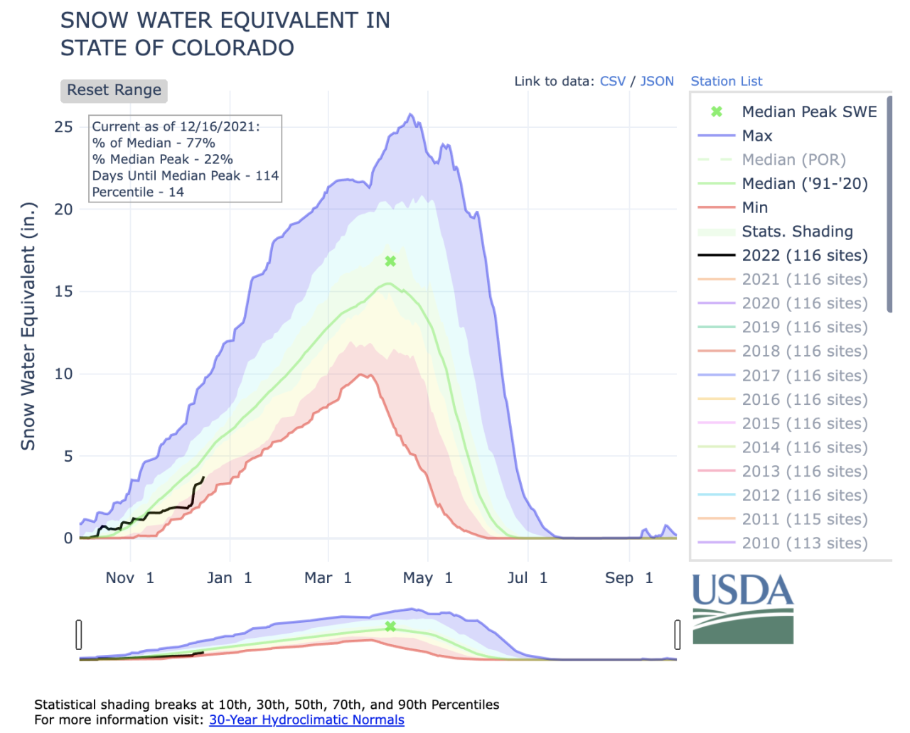
Parts of the mountains got upwards of a foot or two of snow in a storm late last week, and some areas have gotten more snow this week, which boosted statewide snowpack levels to 77% of median as of Thursday – up from 51% of median before the storms over the past week and a half.
The biggest boosts in snowpack were seen in southwestern Colorado.
The San Miguel, Dolores, Animas and San Juan basin jumped from 27% of median snowpack on Dec. 6 to 80% as of Wednesday. The Gunnison basin jumped from 47% of median to 81% over the same timeframe, and the Upper Rio Grande moved from 29% of median to 54% as of Wednesday.
The Upper Colorado Headwaters basin moved from 56% of median to 74%, while the Yampa and White basin went from 59% to 77%. The Arkansas basin moved from 47% to 62% of median this week, while the Laramie and North Platte basin went from 69% of median on Dec. 6 to 81% of median as of Wednesday. The South Plate basin moved from 60% to 65% of median over that period.

The snowpack levels this winter will be key to not only Colorado, but much of the West, as officials worry about river flows in the West, particularly for the Colorado River. Projections released this fall by the U.S. Bureau of Reclamation showed river inflows to Lake Powell and Lake Mead could reach critical levels in 2022 if the drought continues and snowpack continues to be below normal through the winter and melts faster come spring.
