DENVER – The National Weather Service in Boulder upgraded the Denver metro area to be under winter weather advisories on the northern plains to winter storm warnings as a snowstorm moves across Colorado Wednesday.
All of the metro area, southern Weld County, Adams, Morgan, Washington and Yuma counties are now under winter weather advisories until 3 a.m. Thursday for 2-4 inches of snow, winds that could gust to 35 miles per hour, and wind chills that could reach -25 degrees on the Eastern Plains after the NWS upgraded the area to the advisories just after 12:30 p.m. Wednesday.
MORE: Weather blog: Winter weather impacting roads in Colorado
Additional accumulation expected through Thursday. #cowx pic.twitter.com/wUBO17gtxr
— NWS Boulder (@NWSBoulder) January 5, 2022
Northeast Weld County, Logan County, Sedgwick County and Phillips County, as well as northwest Weld County and the lower elevations of Larimer County, are now under winter storm warnings until 3 a.m. – upgraded from winter weather advisories.
The NWS says the Fort Collins area should expect 2-5 inches of snow with gusty winds, and the northeastern part of the state under the warnings could see 4-10 inches of snow, along with 35 mph winds and wind chills near -25 degrees as well.
MORE: Denver7 forecast | Weather Page | Radars | 24/7 Weather Stream | 24/7 Radar Stream | Traffic Conditions
The NWS said 4.5 inches of snow had already fallen by 12:30 p.m. in Proctor – northeast of Sterling. Other areas of Logan County had already gotten more than 5 inches of snow by 1 p.m.
Interstate 76 east of Sterling was closed because of snow and white-out conditions around 1:40 p.m.
More snow and colder. #cowx pic.twitter.com/S0hClrY850
— NWS Boulder (@NWSBoulder) January 5, 2022
Northbound U.S. 287 was closed at 2 p.m. from Ted's Place to the Wyoming border, and U.S. 34 was closed at the Grand Lake entrance to Rocky Mountain National Park.
In addition to the snow and wind on the plains, there are wind chill advisories in effect for most of the Eastern Plains from 11 p.m. to 8 a.m. Thursday, for wind chills that could dip to -25 degrees.
As of 1:30 p.m., snow was starting to move in off the foothills and was falling steadily in northeastern Colorado. The mountains have also been getting snow since Wednesday morning, which is expected to continue through the evening.
Winter storm warnings are in effect for most of the mountains, where some northern areas could see up to 3 feet of snow, including Rabbit Ears Pass, Rocky Mountain National Park and the Medicine Bow Range.
Other mountain ranges could see anywhere between 6 and 15 inches generally – while all of the mountains under the warnings could see blizzard conditions because of winds that could gust as high as 65 mph, according to the NWS.
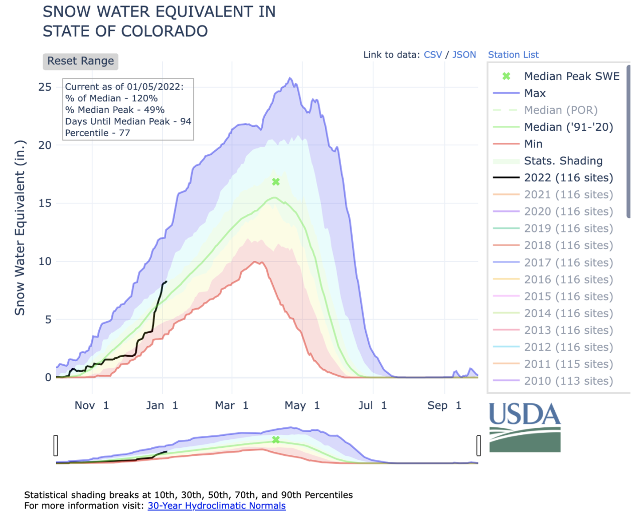
The storm should help further bolster the snowpack across the state, which has grown immensely since the beginning of December. It sat at 51% of median levels on Dec. 7 but had jumped to 77% of median levels as of Dec. 16.
Statewide snowpack was at 120% of median as of Wednesday ahead of the storm. And the Arkansas basin, at 94% of median, was the only basin that was below median levels in Colorado.
The San Miguel, Dolores, Animas and San Juan basin was at 140% of median Wednesday; the Gunnison basin was 150% of median; the Upper Rio Grande basin was 101% of median; the Upper Colorado Headwaters basin was 126% of median; the Yampa and White basin was at 114% of median; the Laramie and North Platte basin was 120% of median; and the South Platte basin was at 109% of median.

You can stay updated as the storm moves into Colorado with the Denver7 weather team and can watch 24/7 live streaming weather updates and radar conditions on the free Denver7+ app.