


UPDATE (Wednesday 11:10 a.m..): Winter storm warnings have been issued for the Denver metro area and foothills. We have a new story up on what to expect Wednesday afternoon. Click here for the latest.
———-
DENVER – The Denver metro area and mountains are still on track for another few inches of snow Wednesday, and the heaviest snow is expected to start around the time of the evening commute.
While highs will reach close to 60 degrees in the metro area on Tuesday, a cold front will move into the area overnight. There could be some light freezing drizzle to start the morning Wednesday in the metro area, according to the latest forecast from the National Weather Service Tuesday morning.
The National Weather Service in Boulder issued a winter storm watch Tuesday afternoon for the metro area, Front Range foothills, and Palmer Divide from Wednesday afternoon through late Wednesday night – with 4 to 8 inches of snow possible and winds up to 35 miles per hour.
⚠ Winter Storm Watches ⚠
— NWS Boulder (@NWSBoulder) February 15, 2022
Winter Storm Watches are in effect for the Foothills and I-25 corridor tomorrow into Thursday morning. Expect 4-8" in these areas with locally higher totals. #cowx pic.twitter.com/dBkDF7ajsk
Snow should start early in the morning in the mountains that will intensify through the morning there.
On the plains and in the metro area, there is still uncertainty Tuesday morning about when exactly the snow will start – whether it will be late in the morning or in the afternoon, according to the NWS.
But the heaviest snow is expected to fall between 4 p.m. and 8 p.m., when snowfall rates could reach a half-inch per hour. The NWS said Denver International Airport, where the official measurements are taken for Denver, should get at least 2 inches of snow after 5 p.m.
Despite the fact we have beautiful, mild weather right now - chilly changes are on the way tomorrow and Thursday! Looks like more "shovel trouble" for Denver and the Front Range! @denverchannel #cowx pic.twitter.com/KvUTwtBoC2
— Mike Nelson (@MikeNelson247) February 15, 2022
There will be some upslope winds with the storm, which favors the heaviest snow in the foothills.
Tuesday morning’s forecast shows around 4-7 inches for Denver, 4-9 inches for Castle Rock, 4-6 inches for Boulder, 5-10 inches for Evergreen, 6-8 inches for Winter Park and 1-3 inches on the Eastern Plains. The northern and central mountains could see upwards of 6 inches, according to Tuesday morning’s forecast.
The snow should mostly taper off after midnight, but flurries could continue through Thursday morning on the Palmer Divide.
Colorado’s statewide snowpack sat at 93% of median Tuesday. Four of the eight river basins were at or above median levels as of Monday’s data — Upper Colorado Headwaters (100%), Gunnison (104%), Laramie and North Platte (101%) and South Platte (105%).
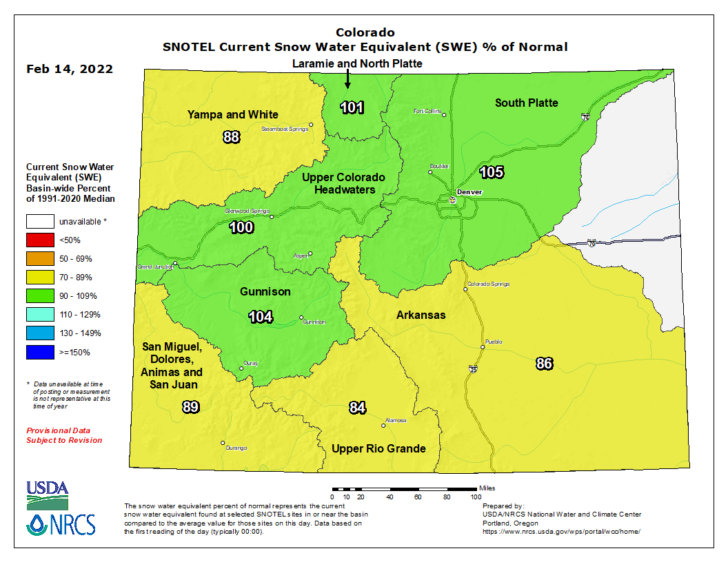
The San Miguel, Dolores, Animas and San Juan (89%), Yampa and White (88%), Arkansas (86%), and Upper Rio Grande (84%) basins were all slightly below median levels.
You can always watch 24/7 weather, radar and news updates on the free Denver7+ app on your TV.
