


DENVER – The forecast for high fire danger Thursday afternoon and rain and snow Friday – including more than a foot of heavy snow in the foothills and mountains – is on track as of midday Thursday, according to forecasts.
Temperatures are expected to reach the upper 80s Thursday afternoon, and red flag warnings are in effect for everything east of the Front Range mountains, and most of the southern and southwestern mountains and valleys as well.
Relative humidity will be as low as 8-15% across most of the warned area, and winds 15-30 miles per hour will persist across the same areas, gusting up to 40-50 mph, according to the National Weather Service.
Hot, dry/breezy today with Red Flag Conditions. A strong storm system will bring drastically colder temperatures & much needed precipitation to North Central/ Northeast CO. Friday-Saturday. Heavy snow expected in & near the Front Range Mountains, Foothills & Palmer Divide. #cowx pic.twitter.com/mXZc5Vrw2G
— NWS Boulder (@NWSBoulder) May 19, 2022
High temperatures will likely fall short of the record of 92 degrees in Denver set in 2020, but there will be high fire danger into the evening hours. The red flag warnings are set to expire at 8 p.m. in the foothills across the eastern plains and 10 p.m. in the Gunnison basin.
But the big changes will start Thursday night in the northern part of the state.
MORE: High fire danger Thursday takes dramatic turn as cold front brings rain, snow Friday and Saturday
The initial strong cold front will shift the winds to a northerly direction and drop temperatures starting around 10 p.m. in the Denver metro area. Light and moderate snow should start in the mountains north of I-70 after midnight, according to the NWS in Boulder.
By sunrise Friday, snow should be falling across the northern mountains and foothills, and some rain could be falling on the northern side of the I-25 corridor. The storm will continue to shift south through the morning and should arrive in the metro area by noon Friday, according to the NWS. But the snow is unlikely to start in earnest in the metro area until after 3 p.m., and the worst impacts will likely not be until closer to sunset and especially after dark, NWS officials said.
All of the metro area, the Palmer Divide and areas of Grand and Park counties are under winter storm warnings, upgraded Thursday afternoon from winter storm watches, with 4-12 inches of snow possible for the storm. Summit County and some of the foothills are also under winter storm warnings for 8-20 inches of snow.
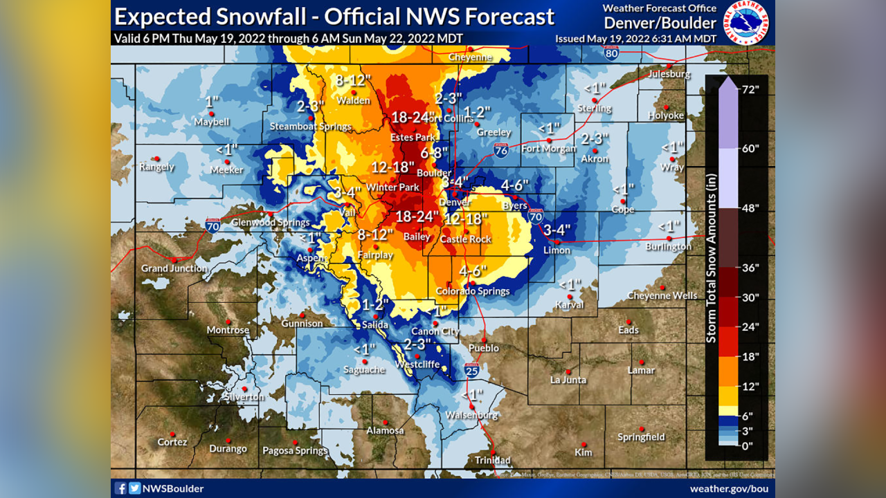
West Jackson and Grand counties, as well as the Vail area, are under winter weather advisories for 4-10 inches of snow.
And a winter storm warning is in effect for the foothills and the areas including Cameron Pass, the Laramie and Medicine Bow mountains, Rabbit Ears Pass, Rocky Mountain National Park, and Nederland, for 12-24 inches of snow between midnight Friday and noon on Saturday.
The NWS says a deep upslope flow should develop by the early afternoon which will increase the precipitation in the foothills and Palmer Divide especially.
The combination of the conditions “will lead to significant and much needed precipitation across the Front Range Mountains, Foothills, adjacent plains and Palmer Divide,” the NWS said in its forecast discussion Wednesday. “The Front Range Foothills and mountains above 7,000 [feet elevation] will likely see significant snowfall from this event with one to two feet of accumulation excepted with locally higher amounts possible.”
In the metro area, current forecasts are looking at 4-10 inches of snow, with higher totals in the southern and western suburbs. But there is still some uncertainty surrounding how much snow will fall depending on how cold it gets and when (latest models are trending toward colder temperatures that would favor snow), how much snow will melt when it hits the ground after several weeks of warm temperatures, and how intense the snowfall might be.
The NWS said if the higher-end snow forecasts hold up, there will likely be damage to trees, most of which have already leafed out across the area, and downed power lines – particularly in the foothills and Palmer Divide, where the snow is likely to be heaviest.
⚠️Heads up 🥺 - tree limbs down 🌳🔽
— NWS Boulder (@NWSBoulder) May 19, 2022
A word of caution about this upcoming storm - heavy wet snow will damage trees. Avoid parking underneath them if possible, and avoid walking under heavily snow loaded trees. Images courtesy of @ColoradoStateU. Please RT. #COwx pic.twitter.com/bfvJib7UbU
Most of the area is likely to see a hard freeze Saturday morning, and possibly again on Sunday morning. So be sure you’ve taken care of your plants, vegetables, and sprinkler systems! The snow should taper off by noon on Saturday.
West of I-25, the snow could contain 1.5 to 2 inches of water, and upwards of half an inch east of I-25, NWS officials said Thursday afternoon.
If snow falls in Denver and at Denver International Airport Friday or Saturday, when temperatures will be closest to freezing and the most moisture will be in the area, it would be among the latest snowfalls in Denver over the past 140 years, according to National Weather Service records.
May 21 holds the 6th-10th spots on record for the latest snow – most recently on May 21, 2019, when Denver saw 2.8 inches of snow at the airport but up to 4.5 inches closer to downtown. June 2, 1951, holds the record for the latest-ever snowfall in Denver, when three-tenths of an inch fell.
Snow in Denver 11 days before meteorological summer? It has happened before! The largest storm was May 25-26, 1950 when 10.7" fell. Late May snow is rare but not unprecedented. The normal date of the last snowfall of the season is April 28th. #COwx pic.twitter.com/qPZ2xiDnFG
— NWS Boulder (@NWSBoulder) May 19, 2022
Over the past 10 years, Denver has seen its last snow four times in May – on May 21, 2019; May 10, 2015; May 12, 2014; and May 2, 2013. The average last snowfall in Denver occurs on April 28.
That should buoy the snowpack in the four northern river basins of Colorado, which is holding on much better than in southern Colorado, where the snowpack is almost gone entirely in two of the basins.

The statewide snowpack sat at 48% of median levels on Thursday before the storm.
Stay with the Denver7 weather team for the latest this week as the storm and forecast develops. You can always watch 24/7 weather, radar and news updates on the free Denver7+ app on your TV.
