


High fire danger has been the big concern for Thursday, but after that a cold and wet spring with the potential for heavy snow and sub-freezing temperatures arrives for Friday and Saturday.
After highs in the upper 80s Thursday afternoon, a strong cold front will sweep across Colorado Thursday night with snow likely from Friday through Saturday for the northern and central mountains and rain changing to snow for Denver and the I-25 Corridor.
The mountains west of the divide could see 4-8 inches of snow above 6,000-7,000 feet with one to two feet of snow above 10,000 feet.
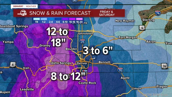
The foothills near and just east of the divide could see 10-18" of snow above 6,000 feet, the heaviest snowfall could be anywhere from Cameron Pass in the north to the Pikes Peak region to the south.
This heavy, wet snow will be a result of the jet stream at 30,000 feet helping to lift the air and create instability in the atmosphere. In addition, a surface from the northeast will also be lifted as it moves over higher terrain. This is an "upslope" scenario and the location of the jet stream will determine which area will see the highest snow totals.
The parched plains and cities in the Denver area and along the I-25 Corridor will see a good soaking rain with some snow, especially over the higher elevations closer to the foothills and along the Palmer Divide south of Denver.
With the current warm temperatures, it is hard to tell just how much snow will stick to the ground, but snow accumulations are expected, especially on the grass and trees. Tree damage will be a concern as many trees have now leafed out and the weight of the snow will likely cause damage. When the snow does arrive, gently and carefully try to shake off some of the snow.
If you are still hoping to ski or snowboard, Mary Jane will be open through Saturday, May 21st, and Arapahoe Basin continues to be open daily, so there could be rather thick powder at both places on Saturday.
If you are driving, roads on the plains and the Denver area should be just wet due to the warm ground. In the foothills between 6,000-10,000 feet, including I-70 from Morrison through Georgetown or even the Eisenhower Tunnel, the roads may well be slushy and snow-packed with winter driving conditions.
Here are snowfall totals along some of the main travel corridors for the upcoming snowstorm. The mountains and foothills have the highest chance of seeing hazardous travel conditions while lower elevations may see a lot of the snow melt on the roadways. Plan ahead! #COwx pic.twitter.com/v7VgGdmxMw
— NWS Boulder (@NWSBoulder) May 19, 2022
The main storm will be from Friday through Saturday, but unsettled weather with showers will linger into Sunday. Another concern will be the sub-freezing temperatures expected in the Denver area and the northeast plains both Saturday and Sunday morning. If you have already planted, CYP — Cover Your Plants — on Friday afternoon before the coldest weather arrives.
If your lawn irrigation system has been turned on, just cover the exposed pipes on the side of the house with a blanket. Turn off the water feed to the system – it is usually attached to the main water pipes and will have a turn off valve. The pipes buried underground will be fine.

Although we would love a nice, warm weekend in mid-May, this type of weather does happen in Colorado every few years. The moisture will be great and the weather will warm up next week!
Click here to watch the Denver7 live weather stream.
