


UPDATE | For the latest updates on this storm, see Denver7's live blog here.
...
DENVER — Long periods of rain on Monday will increase the risk of flash floods for parts of eastern Colorado, including recent burn scar areas and the Front Range.
Sunshine and temperatures in the 80s will give way to scattered and slow-moving storms by the afternoon.
The following alerts are in place, according to the National Weather Service out of Boulder:
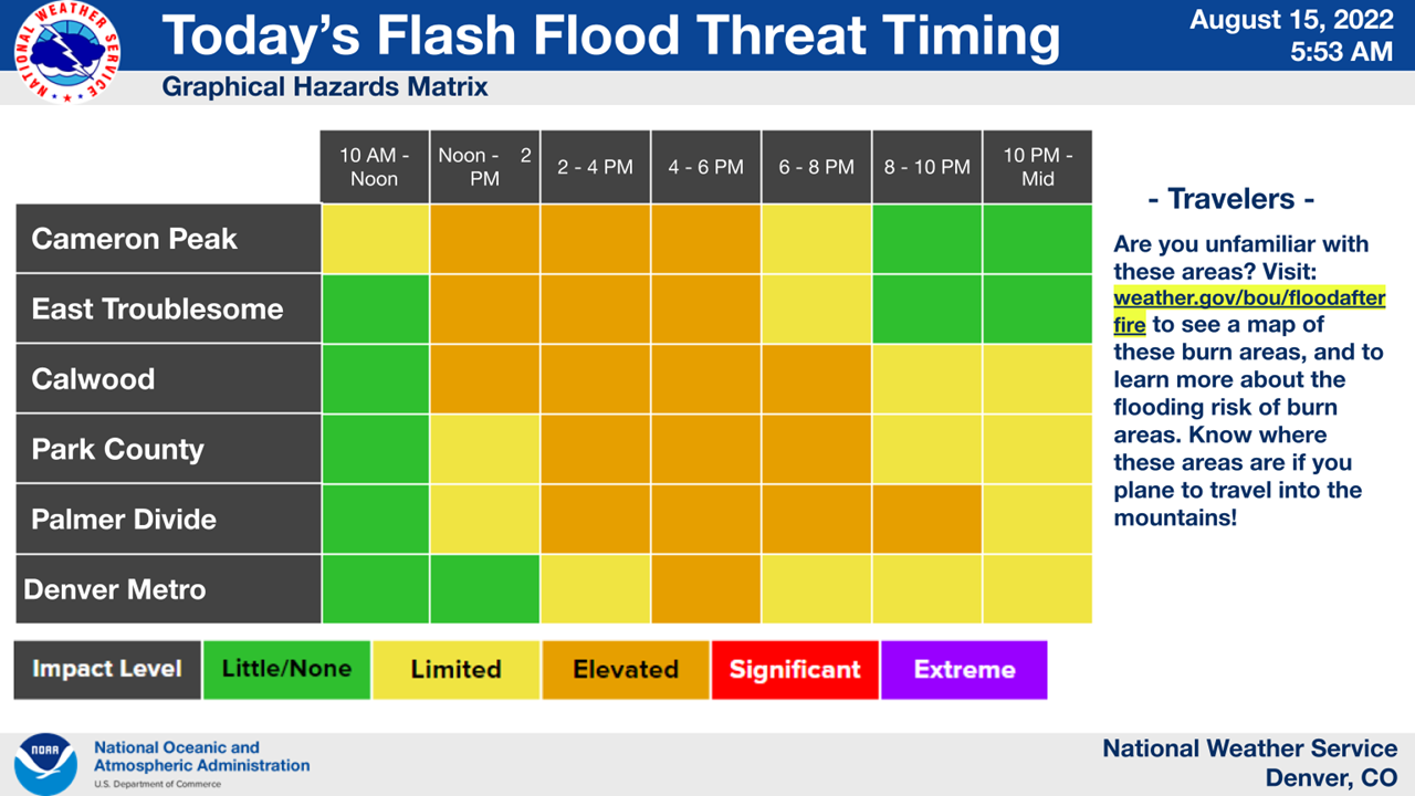
- Flood watch is in effect for the Front Range, Park County and Palmer Divide — including the burn scars for the Cameron Peak Fire, CalWood Fire, Williams Fork Fire, and northeastern portions of East Troublesome Fire — from 1 p.m. to midnight
- Flood watch for Fremont, Teller, Lake, Chaffee, and El Paso counties is in place from 1 p.m. until the evening
- Flash flood warning is in effect until 5:30 p.m. for areas of Larimer County, including Glen Haven, The Retreat, Miller Fork, and Black Creek
Flood watches are issued if flooding is possible, whereas flood warnings are issued when it is already happening or will occur soon.
The Colorado Water Conservation Board reported in its Colorado Flood Threat Bulletin that a high flood threat was issued for the Front Range, including the urban corridor, Palmer Ridge, and northeast plains. Eastern Washington and Yuma counties have an increased likelihood for heavy rainfall overnight, the bulletin says. Local totals may reach 5 inches.
At the maximum, one-hour rain rates may reach 2.5 inches and three-hour rain rates may reach close to 3.5 inches in some spots. Flooding is possible in urban locations, including low-lying areas, roads, gulches and small streams. In higher terrain, mudflows and debris slides are likely, according to the bulletin.

The NWS reported that there is "some threat" in the Denver metro area, but "confidence is lower."
BoulderCAST Weather, which includes a team of meteorologists who monitor Boulder's and Denver's weather, reported that their latest models show thunderstorms entering the two cities between 1:30 and 3:30 p.m. with rain through midnight.
The flood risk is considered moderate for the southwest slopes, central mountains, northern mountains and San Juan mountains, according to the Colorado Flood Threat Bulletin.

The NWS said a few tenths of an inch are likely for areas west of Interstate 25 and south of Interstate 70.
A low risk of flooding is in place for the southeast plains and Grand Valley in Mesa County.
"Moisture is on the upswing across the state with a well-defined monsoon moisture plume still rotating around the High," the Colorado Flood Threat Bulletin reads. "Precipitable water was measured at 1.14 inches and 1.04 inches in Grand Junction and Platteville, respectively, which in the 95th percentile for this time of year! The column of moisture looks impressive in morning soundings, as does the warm layer, so storms should produce some very efficient rain rates with longer duration rainfall and a couple rounds of storms also causing an increase in the flood threat."

Colorado's burn scars, outlined in red in the map above, may be impacted by these heavy rains.
The NWS said the threat is greatest for the Cameron Peak Fire, CalWood Fire, and East Troublesome Fire burn scars starting at noon and tapering off by late afternoon and early evening. These three fires are around the north end of the western red threat warning in the above map.
The Grizzly Creek Fire burn scar in Glenwood Canyon may also see flash flooding and debris flows. A flash flood watch is in effect for this area until an unspecified time Monday evening, according to the NWS.
The NWS is reminding drivers to never drive through flood waters. To sign up for emergency alerts through your county, click here.
A few storms may linger over the mountains on Tuesday, but the threat to burn scars will diminish. Drier weather will continue for much of the week, with afternoon storms possible. The weekend may bring more thunderstorms, according to the NWS.
