


Keep up to date with the latest on weather today and every day with the free Denver7+ app. We also have a live blog running with all the latest developments on today's storm.
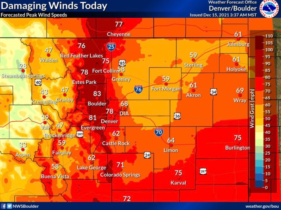
Colorado's Front Range, foothills, and plains will see hurricane-force winds on Wednesday as a strong storm system moves across the state.
MORE: Live updates: High wind warnings across eastern Colorado Wednesday
Multiple high wind warnings are now in effect. Red flag warnings were also issued from 8 a.m. through 5 p.m. Wednesday due to the wind, dry conditions and 14-17% relative humidity, according to the National Weather Service (NWS).

The initial blast of strong winds came through the Front Range between 9 a.m. and 11 a.m., the NWS reported, and will last through 4 p.m.
Here is a breakdown of the multiple weather-related alerts across the state.
High wind warnings across much of eastern half of Colorado
Several counties are under a warning for high wind through 5 p.m. Wednesday:
- Larimer County
- Boulder County
- Jefferson County
- Douglas County
- Gilpin County
- Clear Creek County
- Park County
- Weld County
- Denver County
- Adams County
- Morgan County
- Lincoln County
- Logan County
- Washington County
- Arapahoe County
- Elbert County
- Sedgwick County
- Phillips County
- Broomfield County
This includes the cities of Denver, Lakewood, Aurora, Littleton, Highlands Ranch, Brighton, Greeley, Arvada, Golden, Georgetown, Idaho Springs, Boulder, Nederland, Loveland, Fort Collins, Estes Park, Longmont, Evergreen, Bailey, Fairplay, South Park, Bennett, Kiowa, Eaton, Deer Trail, Haxtun, Parker, Castle Rock, Limon, Brush, Central City, Red Feather Lakes and the surrounding areas.
A few wind reports from the first blast associated with the cold front/showers that moved across the I-25 Corridor - now moving east across the plains.
— NWS Boulder (@NWSBoulder) December 15, 2021
Main blast will start 9:30-11 am when gusts increase to 60-80 mph west of I-25, with a few spots reaching ~100 mph! #COwx pic.twitter.com/bSaFPjCSGV
Wind in these areas will blow 30 to 50 mph with gusts between 60 and 80 mph. Wind-prone places in and near the foothills may see gusts as strong as 100 mph, the NWS reports. Hurricane-force winds are defined as gusts above 74 mph and tropical storm-force winds range from 39 mph to 73 mph, according to the National Hurricane Center.
READ MORE: Delays, closures, cancelations ahead of high wind warning in Colorado
This wind will be strong enough to blow down trees and power lines, which may cause widespread power outages. NWS recommends securing any loose outdoor objects.
Xcel Energy said it will stage crews in the area to quickly restore power if gusts take out lines. If it leads to power outages, customers can report them in the following ways:
- The Xcel Energy mobile app
- Online
- Text "OUT" to 98936 to report, or text "STAT" to the same number to check the status of a power outage
- Call 1-800-895-1999 and follow the prompts
The strong winds will also become a problem on the roads, where high-profile vehicles may get blown around. Avoid travel if you can.
Blowing dust will reduce visibility to less than a quarter of a mile in some places, NWS said.
Mountains in southern Colorado may see gusts up to 95 mph
A high wind warning was issued at 4 a.m. for the Sangre de Cristo Mountain Range, the Wet Mountain Range, and the Wet Mountain Valley. It remains in effect until 5 p.m. for winds that will blow 55 to 75 mph, with gusts up to 95 mph, the NWS said Wednesday morning. Blowing snow will be prevalent on roads in these areas.
In Fremont, Teller and El Paso counties, west winds will blow 40 to 60 mph with gusts up to 80 mph, the NWS said. The high wind warning is in effect in these counties from 8 a.m. to 5 p.m. on Wednesday. Drivers should expect strong cross winds on Interstate 25.
The southeast Colorado plains are under the same high wind warning until 5 p.m. for 35 to 55 mph winds and gusts up to 80 mph, the NWS said. This includes the Walsenburg vicinity, Upper Huerfano River Basin, Trinidad area, Crowley County, Otero County, Las Animas County, Kiowa County, Bent County, Lamar County, Prowers County, Baca County and the Springfield vicinity.
The San Luis Valley is under a high wind warning until noon Wednesday for southwest winds blowing 35 to 45 mph with gusts up to 70 mph, the NWS said.
These dry and windy conditions across the entire eastern half of the state will create critical fire weather on the plains.
Air quality health advisories issued due to blowing dust
These dry, windy conditions have resulted in air quality health advisories due to the blowing dust until 8 p.m. Wednesday. This is in effect for the counties along the Front Range and the eastern plains. A dust storm warning is in effect until 10:30 a.m. for US 350, US 50 near La Junta, US 50 near Las Animas and US 50 near Rocky Ford.
Individuals with respiratory problems should stay inside until the storm passes, the NWS said Wednesday morning. The blowing dust will likely affect people who have heart or lung disease or cardiopulmonary disease.
People with these types of diseases, older adults, and children are encouraged to reduce their activities outside on Wednesday.
These advisories are in effect for the following areas:
- Boulder County (until 4 p.m.)
- Broomfield County (until 4 p.m.)
- Adams County (until 4 p.m.)
- Denver County (until 4 p.m.)
- Jefferson County (until 4 p.m.)
- Arapahoe County (until 4 p.m.)
- Douglas County (until 4 p.m.)
- Larimer County (until 8 p.m.)
- Weld County (until 8 p.m.)
- Morgan County (until 8 p.m.)
- Logan County (until 8 p.m.)
- Sedgwick County (until 8 p.m.)
- Phillips County (until 8 p.m.)
- Washington County (until 8 p.m.)
- Yuma County (until 8 p.m.)
- Elbert County (until 8 p.m.)
- El Paso County (until 8 p.m.)
- Lincoln County (until 8 p.m.)
- Kit Carson County (until 8 p.m.)
- Cheyenne County (until 8 p.m.)
- Pueblo County (until 8 p.m.)
- Crowley County (until 8 p.m.)
- Kiowa County (until 8 p.m.)
- Otero County (until 8 p.m.)
- Bent County (until 8 p.m.)
- Prowers County (until 8 p.m.)
- Huerfano County (until 8 p.m.)
- Las Animas County (until 8 p.m.)
- Baca County (until 8 p.m.)
- Saguache County (until 8 p.m.)
- Rio Grande County (until 8 p.m.)
- Alamosa County (until 8 p.m.)
- Conejos County (until 8 p.m.)
- Costilla County (until 8 p.m.)
Winter weather advisories in place for mountains, I-70 closures expected on and off
Currently, westbound lanes of I-70 are closed from milemarker 195 to 180, and from Silverthorne to milemarker 205.
Multiple snow squalls were issued early Wednesday in the mountains and in El Paso County, but all have ended. The squall also affected southwestern Weld County, western Arapahoe County, Broomfield County, southeastern Larimer County, Denver County, northeastern Jefferson County, western Adams County and eastern Boulder County, according to the NWS.
If you get caught in a squall, NWS recommends pulling off to the side of the road and waiting for it to pass.
In addition to the wind warnings, the National Weather Service has also issued a winter weather advisory for part of Colorado's mountains and western slope.
Rabbit Ears Pass, Rocky Mountain National Park, the Medicine Bow Range, mountains in Summit County, Mosquito Range, and Indian Peaks are all under a winter weather advisory until 8 p.m. Wednesday due to snow — heavy at times, such as two inches per hour — that will start this morning. Total accumulation is expected to stay between 3 and 7 inches. This snow will come in with gusts as strong as 75 mph, which will result in blowing snow and poor visibility, the NWS said. Roads will likely stay slick during this storm, so be sure to drive carefully.
The western Mosquito Range, Sawatch Range, and Sangre de Cristo Range will also stay under a winter weather advisory until 5 p.m. for up to 5 inches of new snow and gusts up to 95 mph. The wind chill may drop to temperatures as low as -30 degrees, meaning frostbite could occur on bare skin in 30 minutes, the NWS warns.
Winds will stay a tiny bit weaker in the La Garita Mountains, the Upper Rio Grande Valley and Eastern San Juan Mountains, but that area is also under the advisory until 5 p.m. due to 1-3 inches of new snow and gusts up to 80 mph.
More winter weather advisory are in effect until tonight farther west for the San Juan Mountains, Elkhead and Park Mountains, Grand and Battlement Mesas, Gore and Elk Mountains, Central Mountain Valleys, West Elk and Sawatch Mountains, Uncompahgre Plateau, Dallas Divide, and Flat Tops. These regions will see 5 to 10 inches of new snow with gusts between 60 and 70 mph.
