


UPDATE (Tuesday, 12:52 p.m.): We have an updated story here that has the latest information on the red flag warnings and high wind warnings. Click here for more.
———-
DENVER – Winds could gust up to 60 miles per hour in Denver and on the plains Tuesday, and up to 80 miles per hour in the foothills and mountains, creating high fire danger into Tuesday evening.
The National Weather Service in Boulder issued high wind warnings for the northern plains, from west of Fort Collins east to Julesburg, as well as the Front Range foothills, Weld, Morgan and Washington counties starting at 6 p.m. Monday and running through Tuesday evening.
MORE: 'It’s essentially 365 days a year': The effect of year-round wildfires in Colorado
Westerly and northwesterly winds are expected to be sustained between 35-45 mph in those areas and could gust up to 60-80 mph, the NWS said Monday.
🔥NEW: All of the northeast Colorado plains have been upgraded to a Red Flag Warning for tomorrow 11 am - 9 pm. Avoid any outdoor activity that may produce a spark and start a wildifre. NO outdoor burning! #COwx pic.twitter.com/Vy0VGnK5Up
— NWS Boulder (@NWSBoulder) April 5, 2022
In the Denver metro area, along the Palmer Divide and the plains east of Denver and Colorado Springs, high wind watches will go into effect on Tuesday morning and last through Tuesday evening. Winds out of the northwest are expected to be a sustained 30-40 mph, with gusts up to 60 mph.
And red flag warnings will be in effect for Yuma, Kit Carson, Cheyenne and Kiowa counties from 11 a.m. Tuesday until 9 p.m., with northwesterly winds 25-35 mph with gusts up to 50 mph, and relative humidities as low as 15%.
The NWS warned Monday the winds could down trees and power lines and lead to power outages.
They will also spread any fires that spark quickly. The NWS said fire danger this week would be elevated-to-critical because of the gusty winds and low humidity levels.
“These strong winds with low humidity will mean near-critical fire weather conditions across much of the northern plains Tuesday afternoon,” NWS forecasters wrote in Monday's forecast discussion.
People are advised to stop any outdoor burns on Tuesday, if possible, avoid using any equipment that could cause sparks, and not to toss any cigarettes out of windows.
The winds will not be limited to the plains and foothills, however. The high country should expect snow to increase after midnight, with 2-5 inches of snow expected in most areas, along with wind gusts up to 70 mph, which could create blowing snow conditions, the NWS said.
Drought conditions along the northern Front Range foothills and in the metro area have improved over the past few weeks, as the metro area up to Fort Collins is rated as abnormally dry on the U.S. Drought Monitor scale. Other parts of the eastern plains are experiencing moderate and severe drought, while most of the mountains are currently seeing moderate drought.
But statewide snowpack dipped last week below 90% of median levels for the past 30 years, though it was back up to 92% of median as of Monday.
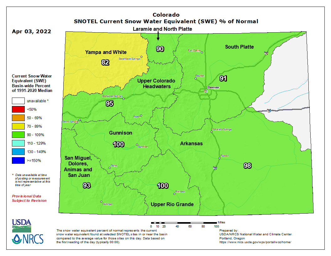
Two river basins – the Gunnison and Upper Rio Grande – were 100% of median on Monday. The Arkansas (98%), Upper Colorado Headwaters (95%), South Platte (91%), Laramie and North Platte (90%), and San Miguel, Dolores, Animas and San Juan (93%) basins were all slightly below median. And the Yampa and White river basin was at 82% of median as of Monday.
People can sign up for emergency alerts for their county by clicking here.
You can always watch 24/7 weather, radar and news updates on the free Denver7+ app on your TV.
