


UPDATE (Thursday, 2:42 p.m.): The full Denver metro area has now been upgraded to a winter storm warning. We have the latest on the forecast for the incoming storm at this new link.
———
DENVER – Get ready for some weather changes to end the week if you’re in northeastern Colorado and the high country, as dry and windy conditions Thursday will precede rain and higher-elevation snow Friday into Saturday, according to the latest forecasts.
Exactly how much snow will fall and at what elevation the snow line will be are two factors still somewhat up in the air as of Wednesday afternoon. But forecasts indicate people above 7,000 feet in elevation and especially those on the eastern slopes of the Continental Divide should expect to see some late-season snow from the storm, as should the metro area.
Temperatures are expected to reach the low 80s on the plains Wednesday, and there will be a chance of storms on the plains as well.
On Thursday, dry, warm, and windy conditions will be in place for north-central and northeastern Colorado, with temperatures in the mid-80s to lower 90s. Fire weather watches and red flag warnings are in effect from the foothills across the eastern plains because of the 15-25 mph winds that could gust up to 40 mph, along with humidity levels in the 10-15 percent range, according to the NWS.

That means there will again be fire danger across eastern and northeastern Colorado, most of which is now experiencing severe drought or worse, as of last week’s U.S. Drought Monitor report.
The wind is expected to shift abruptly from the west-southwest to the north-northeast on Thursday afternoon into the evening as the Canadian front that will bring the cooler weather and precipitation moves into Colorado.
“Confidence is increasing in moderate to heavy snowfall in the Front Range mountains, Foothills and along the Urban Corridor starting late Thursday for the mountains and higher foothills and late Friday for elsewhere through Saturday afternoon,” the NWS said Wednesday afternoon. “There is still a lot of uncertainty in snowfall totals but significant impacts seem likely, especially for broken trees that could lead to power interruptions or outages.”
The snow should start in the northern mountains around midnight going into Friday as the front moves into the area, with more widespread precipitation starting further north then shifting south into the Denver metro area Friday morning, as of Wednesday’s forecasts.
There will be upslope snow conditions in place, which should produce strong precipitation from the foothills down to the metro area and Palmer Divide, according to the NWS. But exactly when and how much snow falls is still coming together in the forecast.
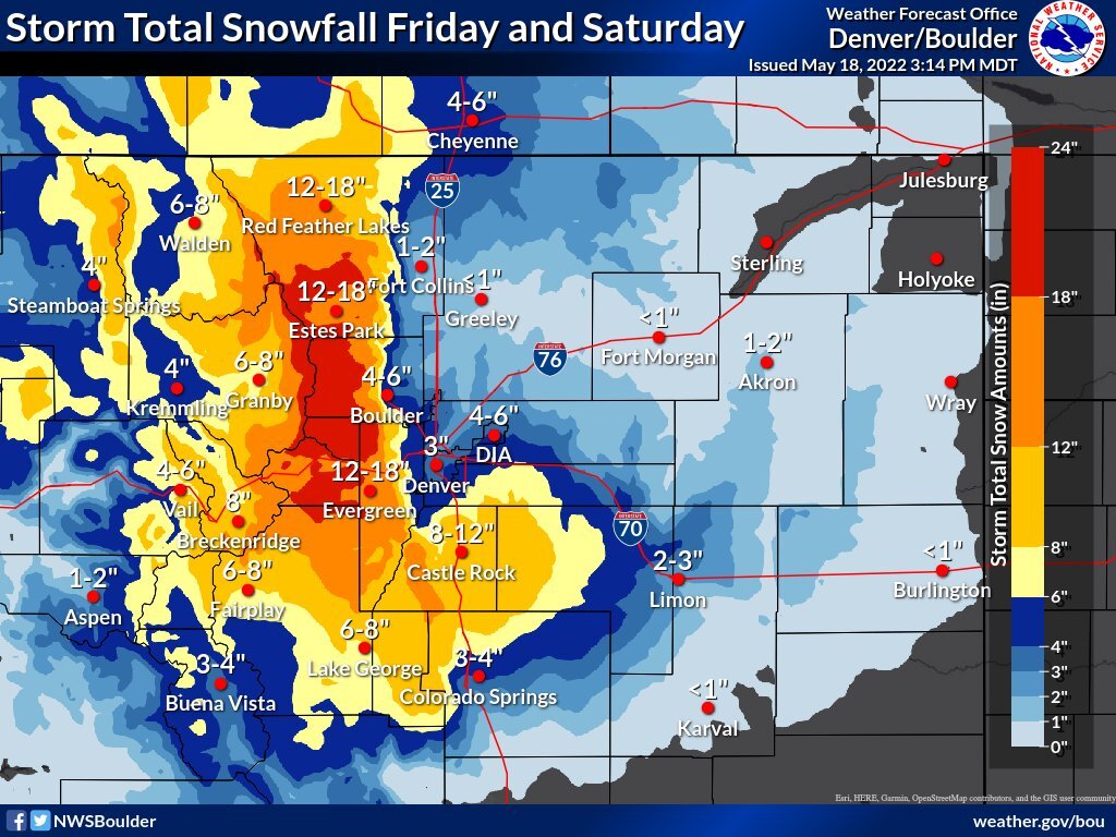
Winter storm watches go into effect late Thursday night through Saturday morning for the Front Range mountains, where 6-18 inches of snow are possible starting Thursday night, according to the National Weather Service in Boulder. In the Elk and Gore mountains, winter weather advisories are in place.
The winter storm watch was extended into the Denver metro area on Wednesday afternoon, with 4-10 inches of snow possible, including 3-6 inches in the lower elevations of the metro area.
❄ Impactful snowstorm incoming! ❄
— NWS Boulder (@NWSBoulder) May 18, 2022
A heavy, wet snow will fall on Friday & Saturday with roughly 3-6" in the Denver metro & around 2 feet near the Continental Divide. Considering leaf out has occurred, downed trees/branches & power outages will be a significant threat. #COwx pic.twitter.com/cEUN3tA09s
In the foothills and Summit County, 4-12 inches of snow are possible between Friday afternoon and Saturday morning, according to the NWS.
Below 7,000 feet, the NWS said Wednesday the forecast is “a little more tricky.”
“At this time, it appears that the rain over the Front Range Urban Corridor may mix and change over to snow Friday night and continue into Saturday morning,” the NWS forecaster wrote in Wednesday morning’s forecast. “The current thinking is that most of the snow should elt as it falls due to warm ground temperatures with mainly light accumulations expected. The Palmer Divide could see a few inches of accumulation due to colder temperatures.”
The NWS forecast said the plains could see a freeze Saturday and Sunday morning, with temperatures flirting with 32 degrees.
If snow falls in Denver and at Denver International Airport Friday or Saturday, when temperatures will be closest to freezing and the most moisture will be in the area, it would be among the latest snowfalls in Denver over the past 140 years, according to National Weather Service records.
May 21 holds the 6th-10th spots on record for the latest snow – most recently on May 21, 2019, when Denver saw 2.8 inches of snow at the airport but up to 4.5 inches closer to downtown. June 2, 1951, holds the record for the latest-ever snowfall in Denver, when three-tenths of an inch fell.
Over the past 10 years, Denver has seen its last snow four times in May – on May 21, 2019; May 10, 2015; May 12, 2014; and May 2, 2013. The average last snowfall in Denver occurs on April 28.
But it’s rare for Denver to see large snowstorms in May. Of the top 20 snowiest Mays, only two have occurred in the 2000s – when 7 inches fell in 2003 and 7.2 inches fell in 2001. There have been numerous years when no snow fell in May in Denver.
Denver has only received a trace of snowfall so far this month and 0.99 inches of precipitation in total for May – below the monthly normal through May 18 of 1.24 inches.
For 2022 so far, Denver has seen 3.94 inches of precipitation (compared to 4.57 inches by this point normally) and 47.1 inches of snow for the season (compared to 47 inches for a normal season for the 1991-2020 period).
The average last freeze in Denver is May 4, but May 22 holds spots 8-10 on the list of latest last freezes. The latest-ever freeze in Denver happened on June 8, 2007. In 2019, Denver saw a freeze on May 22.
Fortunately for northern Colorado, and perhaps more unfortunately for southern Colorado, the northern mountains will see the bulk of the snow in this storm, according to the latest forecasts. Some areas could see upwards of a foot of snow.
That should buoy the snowpack in the four northern river basins of Colorado, which is holding on much better than in southern Colorado, where the snowpack is almost gone entirely in two of the basins.

Snowpack levels sat at 2% of median levels compared to the 1991-2020 period in the Upper Rio Grande basin, and at 3% of median levels in the San Miguel, Dolores, Animas and San Juan basins as of Wednesday. Neither basin is expecting much, if any, snow from the storm.

The Arkansas and Gunnison basins, which have slightly higher chances of snow from the storm, sat at 42% and 40% of median snowpack levels Wednesday, according to U.S. Department of Agriculture and Natural Resources Conservation Service data.
But the storm should help the northern basins – all of which were at or above 50% of median levels Wednesday: Laramie and North Platte (73%); Yampa and White (65%); South Platte (68%); and Upper Colorado Headwaters (50%).

The statewide snowpack sat at 52% of median levels as of Wednesday.
Stay with the Denver7 weather team for the latest this week as the storm and forecast develops. You can always watch 24/7 weather, radar and news updates on the free Denver7+ app on your TV.
