


UPDATE (Wednesday, 6:57 a.m.): A band of heavy snow fell across part of the Denver metro area overnight, dumping more than 7 inches in areas, and snow is expected to continue into the afternoon before bitter cold temperatures set in. We have a new story with the latest on what to expect through the day Wednesday. Click here for more.
————
DENVER – The National Weather Service has upgraded the Denver metro to winter storm warnings early Wednesday due to a band of snow over the metro area. The NWS says another 6 inches of snow could fall under the band.
The Front Range foothills were already upgreaded to winter storm warnings and plains to winter weather advisories ahead of the snowstorm, which hit Tuesday afternoon and will continue to dump snow into late Wednesday.
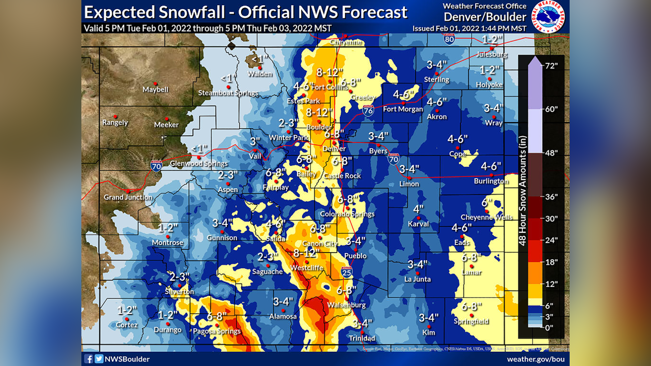
The latest forecast predicts about 4-8 inches of snow in Denver and about 7 to 14 inches for the foothills. Because this will be an upslope snow event, the highest snow totals are expected to be seen in the foothills west of Denver and north to Wyoming, according to the NWS in Boulder.
The snow is not expected to be as heavy east of I-25, with 6-8 inches expected in Castle Rock, 3-4 inches at Denver International Airport and about 6-8 inches in Greeley, the latest NWS forecast says.
The NWS in Boulder said in its updated forecast discussion just before 3 p.m. Tuesday there could be some heavier bands that develop Tuesday evening with snowfall rates of a half-inch to one inch per hour.
The NWS is also watching whether or not conditions will develop to force some of the heavier snow stemming from the upslope conditions further east toward the Denver area.
“At this time, we still think the upslope component will generally win out since there is some forcing aloft as well, but we have nudged up our amounts a couple more inches from the base of the foothills eastward to about I-25,” NWS forecasters said in the update. “…The current Warnings and Advisories will remain unchanged at this point, but be sure to note this forecast is far from certain.”
MORE: Closings and Delays | Full forecast | Radars | Traffic | Weather Page | 24/7 Weather Stream | 24/7 Radar Stream
2/1: Snow increases in coverage this afternoon and continues overnight into tomorrow. This will cause travel impacts to the evening (today) and morning commute tomorrow. #COwx pic.twitter.com/0HR19K4ppK
— NWS Boulder (@NWSBoulder) February 1, 2022
Winter storm warnings are in effect from 2 p.m. Tuesday through all of Wednesday for the foothills in Clear Creek, Gilpin, Jefferson, Douglas, Larimer and Boulder counties, which are expected to get 7-14 inches of snow.
Winter storm warnings for the lower elevations of those counties, including Fort Collins, the city of Boulder, and the western Denver suburbs, went into effect at 5 p.m. Tuesday and run through Wednesday, with 7-11 inches of snow expected.

Denver, Greeley, Castle Rock, South Park and the surrounding areas are under winter weather advisories starting at 5 p.m. and running through Wednesday, with 4-7 inches of snow forecast. Winter weather advisories are also in place for Rocky Mountain National Park, the Medicine Bow Range, Summit County’s mountains, the Mosquito Range and Indian Peaks starting at 2 p.m. for 5-12 inches of snow.
The snow will start over the mountains and foothills and spread into the I-25 corridor. The NWS Boulder forecasters wrote Tuesday morning the snow should start “just in time for the evening commute” in the Denver metro area. The upslope winds should push up snow totals closer to the foothills and west of Denver.
Back by popular demand, here's a look at snowfall totals along I-25, US-36, I-70, and US-285. The highest totals will be across the foothills, where up to 14" of snow will be possible. #cowx
— NWS Boulder (@NWSBoulder) February 1, 2022
As always, feedback is appreciated! pic.twitter.com/k9NIVNGiHp
The eastern plains are under a winter weather advisory for 3-6 inches and winds gusting up to 25 miles per hour from 8 p.m. Tuesday through Wednesday.
Along with the snow, the storm will bring bitterly cold temperatures. Highs on Wednesday are expected to only be in the teens on the plains and in the single digits in the high country, with wind chills in the single digits and below zero.
One the snow and clouds clear out Wednesday night into Thursday morning, low temperatures are expected to fall below zero in the single digits and teens across most of northeastern Colorado.
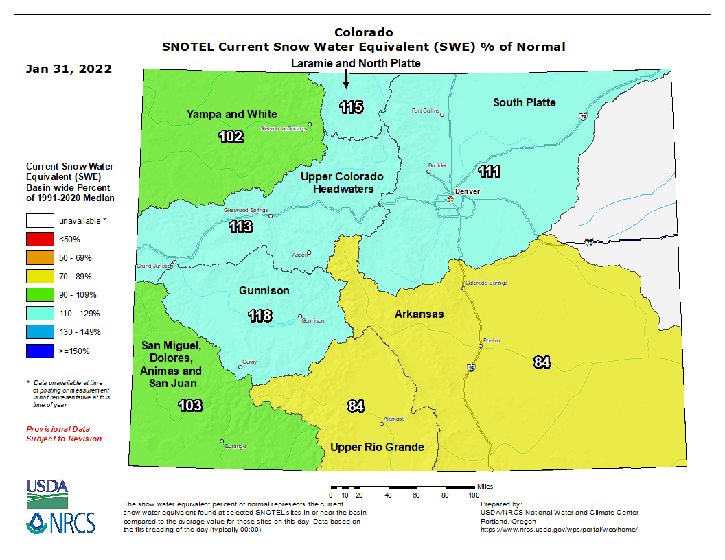
The South Platte and Arkansas river basins should see a boost in snowpack levels from this storm, as southern Colorado is also expected to see significant snowfall, with up to 18 inches in the mountains west of Colorado Springs, Pueblo and Trinidad.
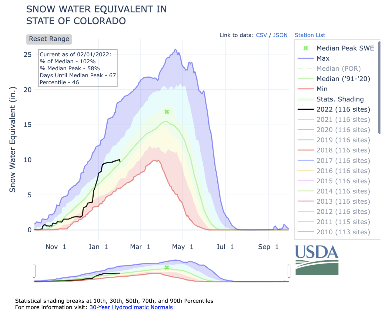
The Arkansas basin and Upper Rio Grande basin were the only two in Colorado that were below median snowpack levels to start the day Tuesday. Statewide snowpack was at 102% of median.
All of Colorado remains under some sort of drought as of this week, and 65% of the state is seeing severe drought or worse conditions.
The Denver metro area and parts of the eastern plains are seeing extreme drought, as is the far northwestern corner of Colorado and about half of the southernmost counties in the state.
You can always watch 24/7 weather, radar and news updates on the free Denver7+ app on your TV.