


DENVER – Colorado’s snowpack sat at 100% of median Friday after this week’s snowstorm and ahead of another storm that will bring snow to the state on Monday, though forecast models are still showing wide variations in how much snow will fall.
The snowpack has increased fairly steadily over the past two weeks after a dry period at the end of January and beginning of March. The foothills west of Denver and Boulder saw the most snow in this week’s storm, but other areas of the state saw a few inches as well.
According to the U.S. Department of Agriculture, Colorado is now 22 days out from seeing its median peak snowpack levels before the spring melt begins.
All eight of the state’s river basins were above 90% median snowpack levels as of Friday. The Gunnison basin (112% of median) had the most robust snowpack, followed by the San Miguel, Dolores, Animas and San Juan (104% of median), the Upper Colorado Headwaters (104% of median), Upper Rio Grande (101% of median), and South Platte (101% of median) basins.
The Laramie and North Platte (99% of median), Arkansas (96% of median), and Yampa and White (91% of median) basins were all slightly below median levels.
The Colorado Basin River Forecast Center released a forecast this week saying the April to July water supply forecasts are near-to-much-below average for the Upper Colorado River Basin and the Great Basin. The water supply guidance for the Upper Colorado Mainstem basin is 65-100% of normal; 75-110% of normal for the Gunnison basin; 65-75% of normal for the Dolores basin; and 65-85% of normal for the San Juan basin.
Inflow forecasts for the Colorado River reservoirs were generally in the 55%-75% range for April-June, except for Blue Mesa Reservoir, whose inflow is forecast at 92%. For that period.
The CBRFC said the coming storm should drop another 0.5” to 0.75” of precipitation at higher elevations, which should further bolster the snowpack.
But there was still wide uncertainty among the different models as to exactly where the system that will move into Colorado late Sunday into Tuesday and how much snow it will bring to Colorado, according to the National Weather Service in Boulder.
Temperatures in Denver on Monday will likely stay around freezing, and there will be precipitation of sorts. But the WCMWF model keeps the system further south, with less precipitation, while the GFS has the storm in northern Colorado with heavier precipitation, according to the NWS.
“Even based on the GFS storm track, would think southeast Colorado into Kansas and Nebraska have the best chance for heavy snow and blizzard conditions,” NWS meteorologists wrote in Friday’s forecast discussion.
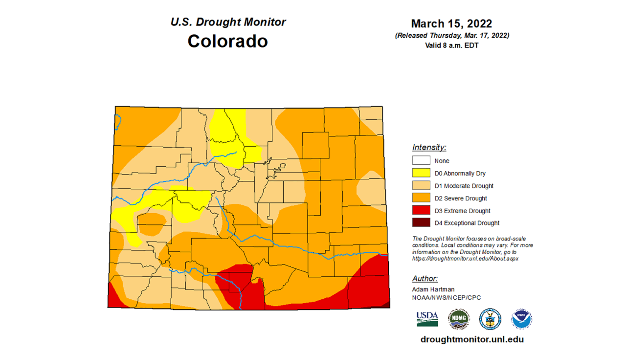
While the snowpack is at 100%, Colorado’s drought remains relatively unchanged again this week. Ninety-two percent of Colorado is experiencing moderate or worse drought. Fifty-seven percent of the state, mostly along the eastern plains, is experiencing severe drought or worse.
And about 8% of the state – mostly along the southern border with New Mexico – is experiencing extreme or exceptional drought conditions, according to the U.S. Drought Monitor.
You can always watch 24/7 weather, radar and news updates on the free Denver7+ app on your TV.
