


DENVER – While northern Colorado is still digging out from this weekend’s snowstorm, which brought more than 2 feet of snow to many areas and blizzard conditions, southeastern Colorado is in for a blizzard of its own starting Tuesday evening.
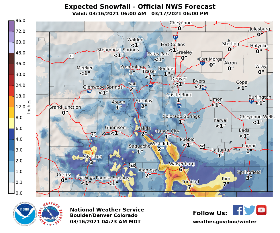
Blizzard warnings have been issued by the National Weather Service in Pueblo for eastern Las Animas County and Baca County. The Las Animas County warning is in effect from 6 p.m. Tuesday through noon Wednesday, where 3 to 7 inches of snow are expected along with winds that are expected to gust up to 65 miles per hour.
The Baca County blizzard warning will go into effect at midnight and run through noon Wednesday. Two to 4 inches, and some locally higher totals, of snow are likely along with wind gusts of up to 65 miles per hour.
The NWS says travel will likely be nearly impossible because of blowing snow and crosswinds, especially along Highway 160.
Winter storm warnings are in effect for the Sangre de Cristo Mountains, the Wet Mountains and valley, and the Walsenburg area from noon Tuesday until 9 a.m. Wednesday, with 8 to 17 inches of snow and winds up to 40 miles per hour forecast.
In western Las Animas County, a winter storm warning is also in effect from 6 p.m. to noon Wednesday. Between 5 and 10 inches of snow are expected along with winds gusting up to 50 miles per hour. The NWS says travel could also be near impossible on I-25 in southern Colorado.
Winter weather advisories are in effect for Fremont County and the Cañon City area, for 2 to 4 inches of snow, for the La Garita Mountains and Eastern San Juans for 2 to 6 inches of snow, and for the Pueblo, La Junta, Las Animas and Lamar areas for 1 to 4 inches of snow and winds up to 55 miles per hour.
Snowfall totals could top 1 foot over Raton Pass as well, along with the gusting winds. The NWS says that the worst conditions will likely occur between 9 p.m. Tuesday and 8 a.m. Wednesday.
The Colorado Department of Transportation says it anticipates several highways closing during the storm, including I-25 from Pueblo to Raton Pass, areas near Walsenburg and Trinidad, Highway 160 over La Veta Pass, and the U.S. 287 corridor including Lamar and Springfield.
🗺Heavy snow/high wind is expected on #I25 from Pueblo south to Raton Pass (to #NewMexico), areas east & west of Walsenburg & Trinidad, along the #US287 corridor (Lamar/Springfield), & #US160 La Veta Pass to encounter severe weather.
— CDOT (@ColoradoDOT) March 16, 2021
📰https://t.co/nysIxHs6fY#KnowBeforeYouGo pic.twitter.com/RqwtLdqm8B
Plow crews will be focusing on I-25, U.S. 50, U.S. 160 and U.S. 287 during the storm and move onto other routes after the storm is over.
“If traveling is required during adverse weather, drivers should NOT seek alternate routes to circumvent road closures, but rather shelter in place or find another safe location to wait out the storm. When a highway is closed due to weather conditions, alternate routes also could be impassable,” CDOT said in a news release.
You can find the latest statewide road conditions here and the latest forecasts and weather alerts from NWS Pueblo by clicking here.
