


UPDATE | Thursday, 8 a.m. — While fire officials said on Wednesday evening that the fire was 125,252 acres, they said Thursday morning that after performing a better assessment of its size overnight, they determined it is actually 121,781 acres. Read Thursday's story here.
...
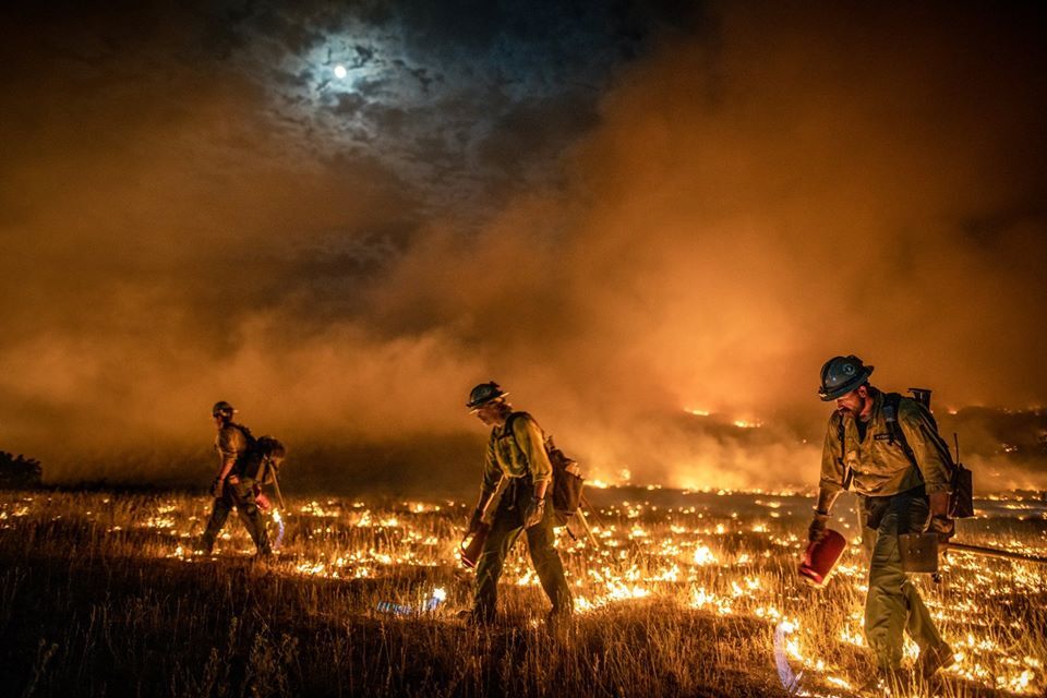
MESA AND GARFIELD COUNTIES, Colo. — The Pine Gulch Fire grew more than 37,000 acres overnight, according to the Rocky Mountain Area Coordination Center. As of Wednesday evening, it was 125,252 acres and the second-largest wildfire in Colorado history.
At more than 125,000 acres, the fire has surpassed the size of the 2018 108,045-acre Spring Fire.
As of Tuesday evening, the fire was 87,778 acres and was 7% contained. Click here for an interactive map of the fire.
The state's 10 largest fires in history, ranked by acreage, are:
1. Hayman Fire (2002): 137,760 acres
2. Pine Gulch Fire (2020): 125,252 acres
3. Spring Fire (2018): 108,045 acres
4. High Park Fire (2012): 87,284 acres
5. Missionary Ridge Fire (2002): 72,962 acres
6. 416 Fire (2018): 54,000 acres
7. Bridger Fire (2008): 45,800 acres
8. Last Chance Fire (2012): 45,000 acres
9. Bear Springs/Callie Marie fires (2011): 44,662 acres
10. 117 Fire (2018): 42,795 acres
The Rocky Mountain Area Coordination Center said the West Fork Complex fire, which burned a total of 109,632 acres in 2013, is not included on this list since it involved three separate fires.
By Wednesday night, significant progress was made securing containment lines along the north, northeast and east sides of the Pine Gulch Fire, increasing overall containment to 14%, according to an update on the fire's Facebook page.
The Rocky Mountain Incident Management Team said earlier Wednesday that firefighting efforts at the Pine Gulch Fire are doing well on the northern and eastern side of the fire, but strong winds from a thunderstorm overnight caused the fire to expand westward. For three to four hours, wind gusts reached speeds of 40 mph at the fire, creating "extreme and erratic fire behavior," according to the incident management team.
In addition, the fire produced hours of lightning Tuesday evening, according to the National Weather Service out of Grand Junction. NWS explained that under the right circumstances, a pyrocumulus cloud can form and create lightning and thunder at the fire.
READ MORE: The Pine Gulch Fire got hot enough to produce lightning. Here's how that works
All firefighters were able to get to safety during the storm.
Fire supervisors were assessing the situation around 8:45 a.m., according to the incident management team.
The incident management team said there is potential for a similar weather pattern Wednesday afternoon and evening as more thunderstorm cells move over the blaze.
New road closures, evacuations Wednesday
The Mesa County Sheriff's Office said Wednesday afternoon that due to fire activity, several roads have been closed to the public.
These are the closures southeast of the fire:
- Roan Creek Road/County Road 204 at North Dry Fork Road/County Road 200
- V 2/10 Road southwest of DeBeque
- Coal Canyon Road just past the Cameo Shooting Range
These are the closures southwest of the fire:
- Highway 139 north of Loma between Mile Point 6 and 39(CDOT closure)
- 21 Road north of the BLM boundary
- 16 Road at V 8/10 Road
- Q 5/10 Road is closed at 18 Road
🚧⚠️UPDATED Detour Map for Western and Mountain areas of Colorado
— CSP Eagle (@CSP_Eagle) August 19, 2020
With the growth of the #PineGulchFire this has prompted the closure of CO139 (Douglas Pass)
I-70 remains closed through the Glenwood Canyon due to the #GrizzlyCreekFire #cotraffic pic.twitter.com/ZurcFBBKhQ
The Garfield County Sheriff's Office also announced new evacuation orders Wednesday through their Facebook page.
Evacuation orders are now in effect for areas on the northwest side of Pine Gulch Fire, as follows:
- From the Mesa County line north to the east/west Colorado Highway 256 (Four A Ridge Road), including north/south Colorado Highway 256
- Highway 256/205 moved from pre-evacuation to full evacuation
- From Highway 139/Douglas Pass road east to the preexisting evacuation order for Carr Creek Road/County Road 207), including Colorado Highway 205 Salt Wash and Kimball Creek Road/County Road 202 on Kimball Mountain. Colorado Highway 258/King Road is evacuated.
Roan Creek Road/County Road 204 above Brush Creek Road/County Road 209 is still under evacuation orders.
Everything west of Douglas Pass/Colorado Highway 139 to the Utah state line is in pre-evacuation status.
Residents who were allowed to return home Tuesday remain in pre-evacuation.
To learn more about evacuations, click here.
The Mesa County Sheriff's Office also said they've created an online Fire Information Resource page to keep residents informed.
Residents in the affected counties can sign up to receive alerts and new information on the fire here for Garfield County and here for Mesa County.
South Metro Brush Engine 41 moved to Division Echo and is fighting the head of the #PineGulchFire, now the 2nd largest fire in Colorado history. This SMFR Wildland Team is seeing extreme fire behavior while supporting burnout operations. pic.twitter.com/5g9xdg35dv
— South Metro Fire Rescue (@SouthMetroPIO) August 19, 2020
The Pine Gulch Fire was first reported on July 31 about 18 miles north of Grand Junction. It was caused by lightning.
RELATED STORIES: Click here for more Denver7 coverage on the Pine Gulch Fire and other current wildfires
Click here to learn more about the smoke outlook in Colorado. A temporary flight restriction is in place over the Pine Gulch Fire. No drones can fly in the area.
The Pine Gulch Fire is one of four major fires currently burning in Colorado that have already scorched more than 175,000 acres of land. The Grizzly Creek Fire has burned 29,000 acres, the Cameron Peak Fire in western Larimer County was 15,738 acres as of Wednesday morning, and the Williams Fork Fire burning in Grand County was 6,726 acres.
