


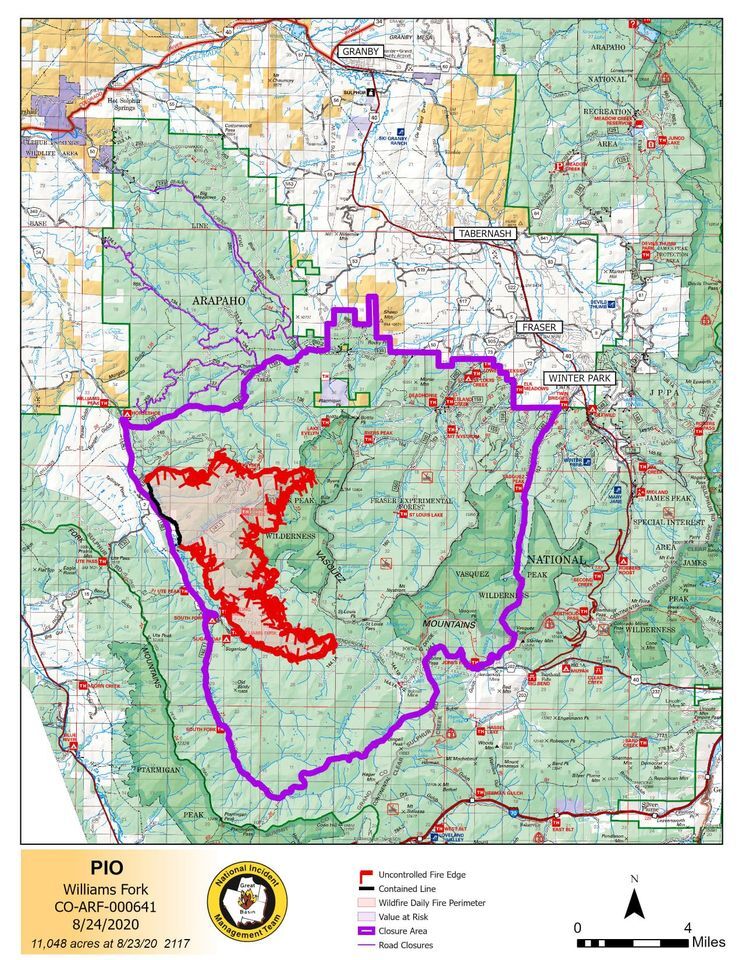
GRAND COUNTY, Colo. – Officials said firefighters continue to make “good progress” on the Williams Fork Fire burning southwest of Fraser, which was 11,048 acres and 3% contained Monday morning.
The fire grew only 235 acres on Sunday, according to fire management. Crews built more lines on the western and southwestern edges of the fire and plan to back burn early this week if weather conditions allow to secure another containment area, officials said.
That will be part of a “contain and confine” strategy, officials said – with the burning operations expected on Monday and Tuesday being part of the containment strategy to create a containment area.
The confinement part of the strategy is being used in other areas of the fire with heavy beetle kill and hard-to-reach spaces by utilizing already-constructed lines, natural features and roads and other man-made features.
“It is often used where terrain and other features do not allow firefighter access and where there are significant risks to firefighter safety and containment success,” fire officials wrote Monday.
Air quality is unhealthy for sensitive groups as of Monday morning but is expected to improve in the afternoon in the Fraser area. But it is worse – deemed unhealthy for all – in the Parshall area Monday and is expected to be classified as “very unhealthy” in the Parshall area on Tuesday.
There were 312 personnel working the fire as of Monday morning, which has been determined to be human-caused. The fire started burning Aug. 19 in the Byers Peak area.
There is another operational update for the fire Monday at 5 p.m. on the fire’s Facebook page.
The Arapaho National Forest said Saturday afternoon that the fire investigation team was asking the public for help in getting information about the start of the fire, which officials have said was caused by humans.
Officials are asking anyone who was in the Williams Fork area the night of Aug. 13 or morning of Aug. 14 and has photos of the area where the fire started to email them to SM.FS.usfsarp@usda.gov. Anyone else with information can call 307-745-2392, option 5, and leave a name and number so law enforcement can call back.
To see an evacuation map, click here. Residents in the area can sign up for evacuation notices through the Grand County Code RED program. There are no current evacuation order for people living in the Fraser Valley, officials said Monday.
The U.S. Forest Service has closed a large area west of Winter Park and Fraser, including roads, trails and campgrounds. All access to the Church Park is closed, including Forest Service Road 133, Forest Service Road 139, County Road 30, County Road 3 (with exemption for mill workers), and County Road 50 starting at Young Life Camp, according to county officials. The Sugarloaf Campground and South Fork Campground were under mandatory evacuation orders when the fire was first reported and have been closed since. County Road 50, County Road 505, County Road 73, Aspen Canyon, Morgan Gulch, and Henderson Mil are under pre-evacuation notice.
The Williams Fork Fire is one of four major fires, and several smaller fires, currently burning in Colorado. Click here for more Denver7 coverage of the wildfires.
