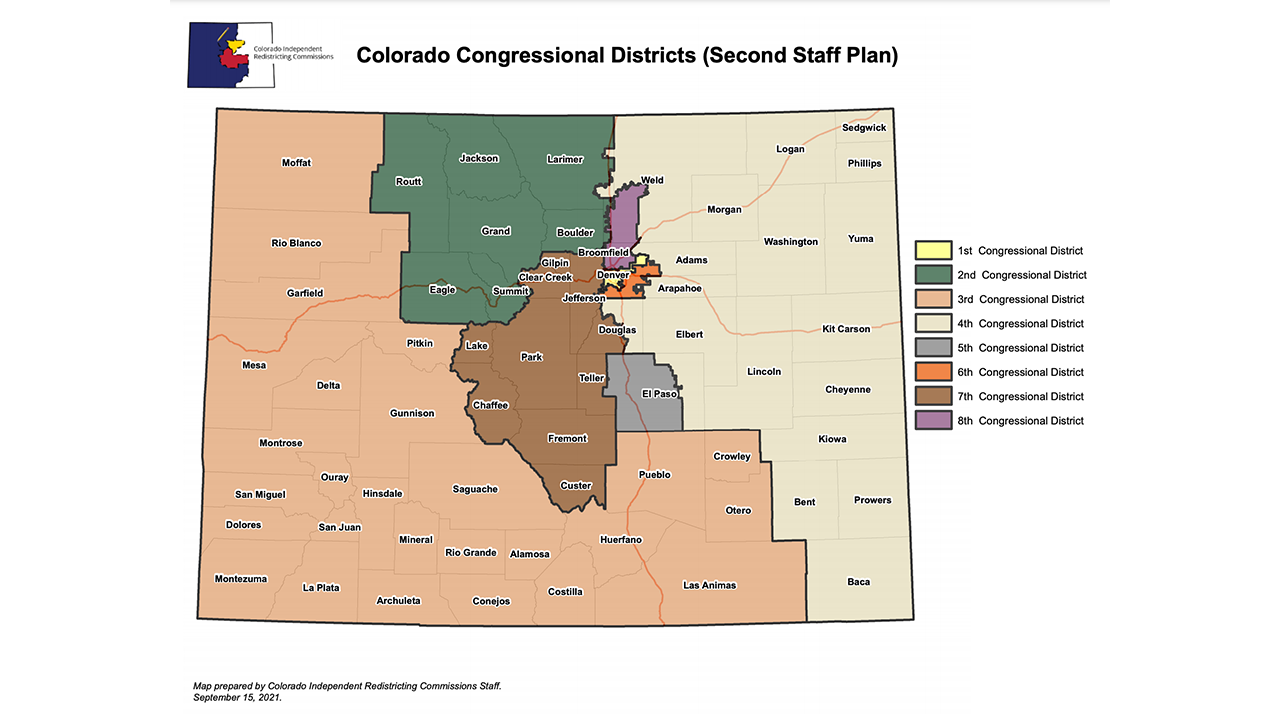


DENVER – The newest draft congressional district map from the state’s independent commission would expand the 3rd Congressional District from the northwest corner of the state down into southeastern Colorado and would create a contiguous 2nd Congressional District in the northern mountain and Front Range counties.
The second map from the staff of the Colorado Independent Congressional Redistrict Commission was released Wednesday and is the second preliminary map drafted by staff this month as the commission works toward a Sept. 28 deadline to adopt a final map to submit to the Colorado Supreme Court.
The latest map no longer puts Reps. Lauren Boebert (R-CO03) and Joe Neguse (D-CO02) in the same district, as did the previously released map. Under the latest proposal, the 3rd Congressional District would include Moffat, Rio Blanco and Garfield counties in northwestern Colorado, down the Western Slope into southwestern Colorado, and east to Pueblo, Crowley, Otero and Las Animas counties.
The 2nd Congressional District would include all of Boulder County except for Clear Creek, most of Larimer County except for Loveland and Wellington, Berthoud, Longmont and Erie, and Eagle, Grand, Jackson, Routt and Summit counties. It puts Fort Collins back into the 2nd district, which had been drawn into the 4th on the previous map.
That would also put the Vail area – where Sen. Kerry Donovan lives, who has announced her candidacy in the 3rd Congressional District race – in the 2nd district, though candidates do not need to live in the district in which they are running or represent.
This week, the commission voted to put staff to work on a new map based off one drawn by commissioner Martha Coleman, a Democratic geographer from Fort Collins. The commission’s nonpartisan staff “cleaned up” her plan, as they said, and worked with her on population adjustments between the proposed districts.
The new proposed 7th Congressional District differs only slightly from the version proposed earlier this month. It includes almost all of Jefferson County but adds in the western half of Douglas County, and also adds in Custer County, along with Broomfield, Chaffee, Clear Creek Fremont, Gilpin, Lake, Park and Teller counties.
The proposed 5th Congressional District includes all of Colorado Springs and most of El Paso County – but the boundaries changes slightly from the previous map.
The 4th Congressional District would span the full Eastern Plains from Baca County in southeastern Colorado up to Sedgwick County. It would also include the most populous parts of Douglas County, the eastern parts of Arapahoe and Adams counties, and most of Weld County, though that county’s more populous areas are included in what would be the state’s new 8th Congressional District. The 4th would also carve out Wellington and the city of Loveland from the 2nd district.
The new 8th Congressional District would include western Adams County and southwestern portions of Weld County, including the cities of Brighton, Commerce City, Northglenn, Thornton, Greeley, Firestone, Frederick, Mead and parts of Arvada, Westminster and Johnstown. The district would be 38.6% Hispanic, according to commission staff, and would be one of three districts, including 1 and 3, that would be at least one-quarter Hispanic.
The 6th Congressional District would include almost all of Aurora, Sheridan, Littleton, Centennial, as well as Columbine, Ken Caryl and the area of Bow Mar that is in Jefferson County.
The 1st Congressional District would remain mostly unchanged from its current boundaries and from the previous map – comprised of nearly all of Denver and the parts of Arapahoe County surrounded by Denver.
Similar to the map released in early September, the latest proposal would likely create a 5-3 map in favor of Democrats – with the 1st (Rep. Diana DeGette), 2nd (Rep. Neguse), and 6th (Rep. Jason Crow) being safe Democratic seats. District 7 (Rep. Ed Perlmutter) would lean Democratic, and the 8th Congressional District would also lean slightly Democratic, though an average of eight statewide elections since 2016 would put it at just +3.9% for Democrats, according to commission staff.
The 4th (Rep. Ken Buck) and 5th (Rep. Doug Lamborn) congressional districts would be safe Republican districts, and the 3rd would be +9.7% for Republicans, according to the same average of those eight statewide elections.
The plan is set to be presented to the commission Thursday night at 6 p.m. Public hearings on the map wrapped up last week, but people can still submit written public comment throughout the process by clicking here.
The commission is allowed to approve a map anytime through Sept. 28 and will have to submit it to the Colorado Supreme Court by Oct. 1.
