


Colorado's mountains are receiving some much-needed snow as a strong snowstorm moves across the state, but is causing many headaches and hazardous conditions for travelers.
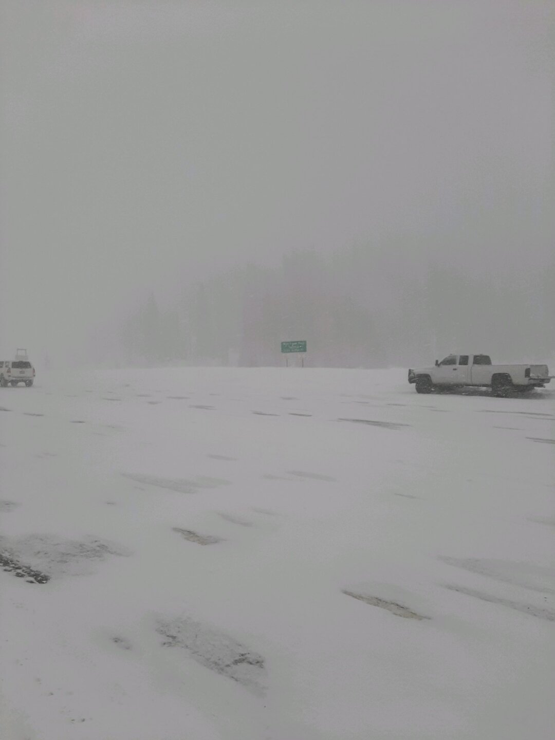
The storm began Thursday and will stick around through Saturday morning. A Winter Storm Watch is in effect for several areas in the mountains, which may see 10 to 20 inches of new accumulation. Colorado State Patrol is urging drivers to stay at home if possible, as roads will become increasingly dangerous as the storm piles snow in the high country.
LEARN MORE: Today's forecast | Live weather radar | Interactive radar | Weather alerts | Driving in wintry weather | Live traffic radar
Below are the latest updates on this storm.
Saturday
3:30 p.m. | Denver and the rest of the metro area might not have experienced a white Christmas this year, but that wasn't the case for the mountains. Check out the snow totals from this latest storm here.
Friday
7:43 p.m. | US-550 northbound and southbound between County Road 31 and County Road 20D have been reopened.
6:49 p.m. | US-550 northbound and southbound is closed between County Road 31 and County Road 20D due to snow removal.
6:41 p.m. | Brush Creek is now reopen. Drivers are urged to travel with caution.
4:51 p.m. | Brush Creek will be closed from the lower roundabout to Highway 82 until further notice due to icy conditions.
4:11 p.m. | I-70 eastbound between Edwards and Avon is closed due to safety concerns.
#I70 eastbound: Road closed due to safety concerns between Exit 163 - Edwards and Exit 167 - Avon. https://t.co/VT7VjvpPS7
— Colorado Department of Transportation (CDOT) (@ColoradoDOT) December 24, 2021
3:45 p.m. | The National Weather Service says a band of rain/snow is continuing to move southeast onto the plains. Southeast Park County may briefly experience heavy snowfall rates while it exits. Portions of the plains will see a period of rain.
12/24 3:45 PM: A band of rain/snow continues to move SE onto the plains. SE Park County may briefly experience heavy snowfall rates while it exits. Portions of the plains will see a period of rain. #COwx pic.twitter.com/ZuMeZPmAU4
— NWS Boulder (@NWSBoulder) December 24, 2021
1:42 p.m. | Westbound lanes of I-70 near the exit for Hanging Lake have reopened following a rockslide earlier today.

1:39 p.m. | I-70 eastbound reopened between east Frisco and the Loveland Pass exit.
1:35 p.m. | US 550 northbound has closed due to an avalanche between Lime Creek (near Coal Bank Pass) and First Street (near Molas Divide). The closure runs for about 20 miles south of Silverton.
1:06 p.m. | The NWS out of Grand Junction said a heavy band of snow from Gateway to Carbondale brought the first measurable snow of the season to the Grand Junction Regional Airport. So far, totals are about an inch.
Noon | Eastbound I-70 is closed between east Frisco and Loveland Pass. CDOT is calling this a safety closure. CSP Master Trooper Cutler said the call for this came in at 12:07 p.m. and reported two cars had crashed.
11:41 a.m. | A rockslide has closed the westbound lanes of I-70 at exit 125 for Hanging Lake. CDOT said drivers should expect delays.
11:30 a.m. | Denver7's Jason Gruenauer and Katie LaSalle provide an updated in-depth look at weather and road conditions across Colorado as this storm continues in the mountains.
11:11 a.m. | CSP in Durango is recommending residents and visitors avoid all non-emergency travel due to hazardous conditions, especially around Wolf Creek.
9:47 a.m. | Westbound I-70 is closed between Copper Mountain and Vail Pass due to safety concerns.
9 a.m. | Eastbound lanes of I-70 briefly closed between Silverthorne and the exit for Loveland Pass, but the lanes are back open. The closure lasted about 30 minutes.
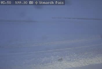
7:40 a.m. | Monarch Pass is closed due to an avalanche on the Chaffee County side (north/east), according to Gunnison Regional 911 Center.
7:30 a.m. | Heavy wind-driven snow will continue across the eastern San Juan mountains today, according to the NWS out of Pueblo. Travel will remain hazardous especially as winds increase again today in southern Colorado.
7:10 a.m. | Watson Divide is closed in both directions from Snowmass Creek to Highway 82 due to unsafe driving conditions, according to the Pitkin County Sheriff's Office.
7 a.m. | Avalanche warnings are in effect around the state, with the exception of the Sangre de Cristo range. Heavy snow and strong winds are creating very dangerous avalanche conditions, according to the Colorado Avalanche Information Center. Expect very large avalanches to run naturally and long distances on Friday. Travel in avalanche terrain is not recommended. Click here to read more.
Aspen Mountain Patrol will set off charges for avalanche mitigation from 7:45-9 a.m. today.
6:05 a.m. | Highway 24 closed between Red Cliff and Camp Hale, according to CSP in Eagle, due to a crash. Use Highway 91 and I-70 as detour.
2:20 a.m. | Strong cross winds will continue to impact the southern I-25 corridor this morning — a danger for lightweight high-profile vehicles. Gusts up to 70 mph have been reported by sensors along I-25 south of Colorado City, the NWS said.
Thursday
10:29 p.m. | Eastbound and westbound Highway 6 between I-70 and Montezuma Road is shut down due to safety concerns.
10:26 p.m. | The National Weather Service says travel conditions will continue to deteriorate as snow moves into the mountains. Officials say conditions will stay poor through Friday. If you can, stay off the roads. If you need to travel, take extreme precautions.
Snow is increasing over the mountains this evening, and will get heavier overnight! Travel conditions will continue to deteriorate (like Highway 40 already has over Rabbit Ears/Muddy Pass), and will stay poor through Friday with more snow. #COwx pic.twitter.com/7iGAwo8dEh
— NWS Boulder (@NWSBoulder) December 24, 2021
5:35 p.m. | The westbound lanes of I-70 have reopened between Copper Mountain over Vail Pass, CDOT says. Drive carefully out there!
5:24 p.m. | The westbound lanes of I-70 are closed from Copper Mountain over Vail Pass "due to extreme weather conditions," the CSP in Golden says.
10:52 a.m. | A new update from the NWS details how the storm will hit Thursday and Friday. Snow will become more widespread and heavier in the mountains late tonight and overnight. Snowfall rates will increase to an inch or two per hour tonight in the Park Range, with lighter rates in other places.
Conditions will worsen through Friday.
The Winter Storm Warning will continue for the northern mountain areas roughly along and north of a line from Rabbit Ears Pass to Rocky Mountain National Park, with an advisory for North Park and the I-70 Summit County corridor, NWS reported.
8:05 a.m. | Avalanche Watches are in effect throughout the state as this significant storm moves into Colorado. The danger will rise statewide as accumulation begins. All of Colorado Avalanche Information Center's zones are under the water, with the exception of the Sangre de Cristo Mountains.

7:44 a.m. | A High Wind Warning is in effect for eastern Costilla County and nearby areas from 8 p.m. tonight through 8 p.m. Friday. Southwest winds will blow 35 to 45 mph, with gusts up to 80 mph expected. Crosswinds on I-25 will result in hazardous travel for high-profile vehicles.
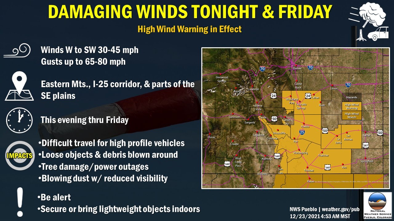
7:05 a.m. | Colorado State Patrol in Larimer County said high wind gusts were whipping around Interstate 25 and Highway 287. CSP is asking drivers to use caution when driving around Red Feather and Highway 14 now through Saturday due to the high wind and incoming snow.
5 a.m. | While the Denver metro area will stay in the 50s and 60s through Christmas Day, the mountains will see another round of much-needed snow later this week, according to the National Weather Service. Click here for a full breakdown.
