


A cold front will dump several inches of snow across some of Colorado's mountains on Tuesday, while bringing gusts of wind up to 60 mph to the Front Range and plains well into the evening hours.
Rain and mountain snow will continue to move over the Central Rockies Tuesday afternoon and will progressively weaken throughout the day, according to the National Weather Service.
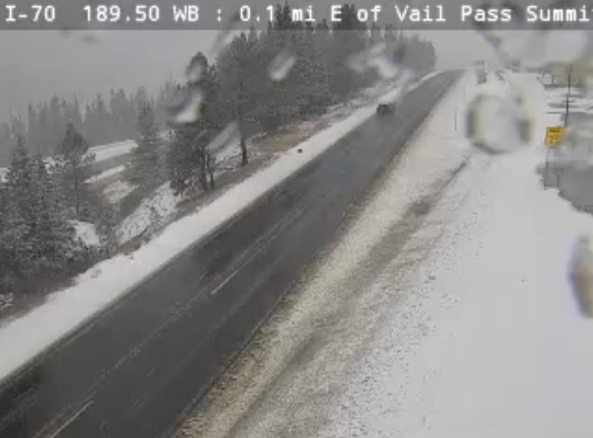
As of noon, the storm was creating slick roads around Vail Pass and the Eisenhower Tunnel.
Following a brief lull in the storm, another band of snow will move through in mid to late afternoon.
Snow totals may reach between 4 and 8 inches in the Park Range and Gore Range. Totals will stay closer to 2 to 6 inches from the I-70 corridor north to Rocky Mountain National Park by Thursday morning, according to the NWS.
The Colorado Avalanche Information Center said the chance of triggering an avalanche increases Tuesday and Wednesday, particularly on north- and east-facing slopes at high elevation, where deep early-season snow is lingering.
The storm isn't harsh enough to warrant a Winter Weather Advisory along I-70, however a Snow Squall Warning may be issued later in the day, NWS said. Snow squalls are short, but intense, periods of moderate to heavy snowfall. Road conditions may deteriorate quickly if this occurs.
The NWS issued a few Winter Weather Advisories for Tuesday's storm. One covers west Jackson County and west Grand County, both above 9,000 feet. Those advisories will expire at midnight.
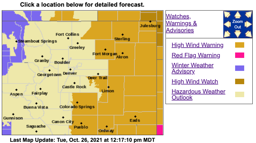
The southwest San Juan Mountains and northwest San Juan Mountains, as well as the Elkhead Mountains, Park Mountains, Grand and Battlement Mesas and Flat Tops are also under a Winter Weather Advisory until midnight.
Travel will likely be difficult in areas where a Winter Weather Advisory is in place due to blowing snow and slick roads.
The intensity of the snowstorm will decrease into the afternoon and evening once the cold front moves past the mountains, the NWS said.
READ MORE: Today's forecast | Future forecasts | Live radars
Around noon, the front will move out of the foothills, reaching Denver around 1 p.m. It may bring some showers to the city, but it won't amount to much.
By the early evening, around 5 to 7 p.m., another cold front will roll down from Wyoming onto the eastern plains. This one will bring heavier showers and thunderstorms than the earlier system. The Palmer Divide northeast toward Sterling will see the best chance of these storms, according to NWS. Small hail or graupel is possible.
On the plains, High Wind Warnings will go into effect at 6 p.m. for much of eastern Colorado, where gusts may reach 60 mph. The flowing areas fall under this warning:
- North and eastern Elbert County below 6,000 feet (ends at 3 a.m. Wednesday)
- Lincoln County (ends at 3 a.m. Wednesday)
- Logan County (ends at midnight)
- Northeast Weld County (ends at midnight)
- Phillips County (ends at midnight)
- Sedgwick County (ends at midnight)
- Washington County (ends at midnight)
- Morgan County (ends at midnight)
- Yuma County (ends at midnight)
- Kit Carson County (ends at midnight)
- Cheyenne County (ends at midnight)
A High Wind Warning is also in effect starting at 5 p.m. for El Paso, Pueblo, Crowley, Otero, Bent, Kiowa and Prowers Counties until 3 a.m. Wednesday, according to the NWS.
The NWS said the wind will make for difficult driving conditions, especially for drivers of high-profile vehicles, along Interstate 25 with gusts expected to reach 50 to 55 mph.
The storms will move out Tuesday evening.
By Wednesday, skies will clear, but conditions will stay gusty for much of the day. Temperatures will reach highs near 60 around Denver, according to the NWS.
The end of the week is expected to stay dry and calm ahead of Halloween weekend.
Denver typically sees a few snowstorms in October, but that has yet to happen in 2021. The average snowfall in the city in October is 4.1 inches.
In both 2010 and 2016, Denver didn't see its first snow until mid-November.

The snowiest October on record was in 1969, when 31.2 inches fell on the city.
