


DENVER – The calendar turned to June on Saturday and our statewide snowpack was 437% of normal, with highs peaking at 768% in the San Juan Mountains, according to the Natural Resources Conservation Service.
The heavy snowfall this year has been a good thing for skiing (with Arapahoe Basin still open) and the drought conditions – all of Colorado was drought-free as of this week.
But heading into summer, the snowpack is likely to result in some flooding, according to the Colorado Water Conservation Board, which released a report this week on the outlook for snowmelt flood conditions.
More |Swift water rescue crews warn of deadly 'big water' year on Colorado rivers after record snowpack
Here's what to watch for as we should start to see an uptick in snow runoff.
The snowpack
The statewide snowpack percentage has risen over this week, with local figures ranging from 228% in the North Platte basin to 768% in the San Juans. Here are the latest figures from around the state, according to the NRCS:
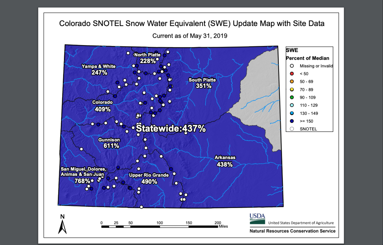
The snow water equivalent
When we talk about snowpack, the snow water equivalent, or SWE, is the key figure to keep in mind. The SWE, as the NRCS explains, is the amount of water contained within the snowpack, or the depth of water that would result if all of the snow was melted at once.
The SWE in the Colorado mountains peaked at 20.5 inches in April and was still around 16.5 inches this week, according to the National Weather Service in Boulder. That's way ahead of where we were this time last year, with about 1.5 inches of SWE, and ahead of our normal SWE this time of year, which is 4.5-6 inches.
At the same time, the SWE numbers this year are still lower than the highs in 2011 and 1995.
Snowpack snow water equivalent (SWE) in the NC CO mountains peaked at ~20.5” on April 15th, and is still estimated at 16.5" today. On this date last year there was only ~1.5" SWE. The normal SWE on this date is 4.5” to 6". Map courtesy of the NRCS. #cowx pic.twitter.com/bd9vocb7cE
— NWS Boulder (@NWSBoulder) May 30, 2019
Runoff forecasts
The main thing to keep in mind is that much of the snowpack isn't melting yet. Only 38% of the statewide snowpack has melted, according to the Conservation Board, after snowmelt slowed "significantly" during the second half of May. This resulted in a heightened risk of snowmelt flooding.
Once the runoff increases, those extremely high snowpack percentages will drop quickly. The Conservation Board says it's important to keep the numbers in perspective:
"What happens as runoff season progresses is that the average snowpack drops very quickly as snow runs off in an average year. This lowers the denominator in the equation to increasingly smaller numbers, which can result in extremely high percents of average. The thing to keep in mind for this year is that snowpack is holding on late, not that enormous actual snowpack numbers are being observed. However, this does significantly increase the risk of snowmelt flooding as a much higher amount of snow is still available to melt as the state heads into the much warmer month of June."
The bottom line
Major floods in Colorado have generally happened as a result of rainfall, not snowmelt. That doesn't mean localized snowmelt flooding won't happen, especially as temperatures rise this month. In fact, the Conservation Board says localized and isolated flooding from snowmelt is already happening and likely to continue throughout the runoff season.
But widespread flooding as a result of snowmelt "is possible, but unlikely this year," the Conservation Board says.
