


As Denverites wait for their first snow of the season, parts of the high country could see a few inches of new snow by the end of the day Wednesday.
Snow fell over Colorado's central and northern mountains Wednesday morning, with up to 8 inches possible in a few places over 10,000 feet, especially in north Colorado. Wind gusts may reach up to 50 mph in the mountains, with wind-prone areas along the Front Range seeing gusts as strong as 60 to 70 mph, according to the National Weather Service.
The mountain peaks northeast of Steamboat Springs will see the most new snow, as well as the Interstate 70 between Vail and Georgetown and north along the Continental Divide.

Higher mountain passes may become tricky for drivers due to slushy or snow-covered roads until mid-morning Wednesday.
Colorado State Patrol out of Eagle said its troopers responded to several crashes Wednesday morning.
Roads in the mountains are very icy this morning in areas. Please slow down and give yourself plenty of extra time to get to your destination. Troopers are responding to several crashes already throughout the mountain corridor. pic.twitter.com/SCcSEbbfDY
— CSP Eagle (@CSP_Eagle) November 10, 2021
Some of these mountain storms will linger overnight into Thursday, but snowfall will stay lighter by that point, according to the NWS.
A Winter Weather Advisory is in effect for the Elkhead and Park Mountains and Flat Tops above 9,000 feet until noon Wednesday.
LEARN MORE: 24/7 WEATHER STREAM | TODAY'S FORECAST | INTERACTIVE RADARS
By midday, most of the snowfall will stop over the mountains.
Meanwhile, at lower elevations, conditions will stay dry Wednesday, the NWS reports. The plains will see some wind in the morning — with gusts up to 40 mph — but this will die down closer to the Denver metro and Fort Collins areas. Winds for most of the plains should weaken later today.
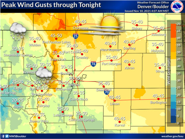
Farther south, parts of El Paso County and Pueblo County are under a Red Flag Warning until 6 p.m. due to the gusty winds and low relative humidity. The wind around Fort Carson, Colorado Springs, and Pueblo is expected to hover around 10 to 20 mph, with gusts up to 30 mph, according to the NWS. A Red Flag Warning means that conditions are favorable for rapid fire spread.
The eastern plains has a slight chance of seeing a rain-snow mix by Thursday around the evening commute. At worst, it will make roads a little wet. Some flurries may stick around Friday, but it won't be nearly enough to count as the first official snowfall of the season.
According to the NWS, the dates of the top 10 latest first snows to hit Denver start in mid-November. The latest first snow on record for the city is Nov. 21, 1934.
