


Prime conditions for fires will persist throughout this week in Colorado, especially for the southern part of the state.
The NWS out of Pueblo reported Monday: "Extremely critical fire weather conditions have been placed on our outlook today again as well — a statistically rare event that's been occurring with alarming frequency as of late — meaning that conditions today are volatile and dangerous, and any fire that sparks could quickly grow out of control and rapidly intensify."
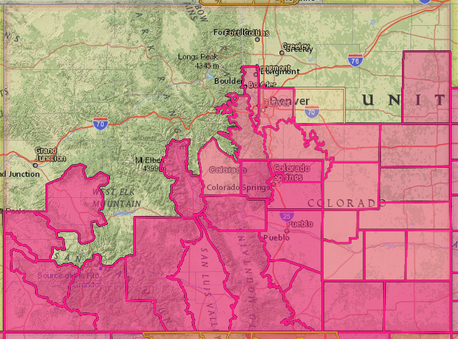
Red flag warnings, which indicate critical fire weather conditions are in place or will be soon, are in effect through 9 p.m. Monday due to low relative humidity — roughly 6-7% — and strong winds. The warning covers the below areas in pink until Monday evening, when it expires.
It includes the Upper Arkansas River Valley, South Park, the southern Front Range and foothills, Palmer Divide, Denver metro area, Sangre de Cristo Mountains, Wet Mountains, San Luis Valley, southeast plains, and Fremont, Teller, El Paso and Pueblo counties.
These strong winds are blowing up enough dust to be spotted from satellites, the NWS said, and it may make north-south travel difficult. That dust is moving into the state from New Mexico.
The winds are expected to calm down a bit by the afternoon, though lingering strong gusts can still cause damage.
Come Tuesday afternoon and evening, critical fire weather conditions will spread across much of south central and southeast Colorado, where 20-25 winds are expected with 35 to 45 mph gusts.
These conditions are optimal for rapid fire spread, NWS said.
Fire weather concerns continue on Tuesday, with critical fire weather conditions expected over much of south central and southeast Colorado. #cowx pic.twitter.com/oW1usxPjfV
— NWS Pueblo (@NWSPueblo) May 9, 2022
Red flag warnings will return from 11 a.m. to 9 p.m. Tuesday for the Continental Divide, San Luis Valley, Sangre de Cristo Mountains, the Wet Mountains, and Teller, Fremont, Pueblo, Huerfano, Las Animas and Baca counties.
A fire weather watch, which means that critical fire weather conditions are in the forecast, is in effect for the same timeframe for Crowley, Otero, Bent, Prowers, and Kiowa counties.
A fire weather watch will also effect the southern foothills, Palmer Divide and adjacent plains north through Denver and east and south through Lincoln County, the NWS said. This watch begins at 11 a.m. Tuesday and expires at 9 p.m.
The high fire danger across the state's southern counties will continue Wednesday through Friday and possibly into the weekend, the NWS said. Thunderstorms are possible Wednesday over the far eastern plains, with some strong to severe storms possible, but otherwise, "critical to possibly extremely critical" fire weather conditions will persist for southern Colorado.
Much of Colorado should expect to see another fire weather watch, and possible more red flag warnings, on Wednesday. A cold front will move in Thursday, though temperatures will stay above normal.
"Looks like persistent warm and dry weather," the NWS said.
