

DENVER — More spring snow is on the way for Denver and the rest of Colorado's Front Range. And like last week's storm, we could see several decent snow totals across the metro area.
Here's what to expect, and when, via the National Weather Service in Boulder and our Denver7 meteorologists:
Timeline
A cold front moved into the area Monday morning. And while temperatures could climb into the 40s by Monday afternoon, they'll only get colder as the day goes on, with a second front dropping temps into the 20s by the evening hours. Most of the Front Range, including Denver, was under a winter weather advisory on Monday, and some areas of the foothills were under a winter storm warning.
Heavy snow is expected to start falling over the northern mountains by Monday afternoon, with the snow spreading south into the Denver metro area by around 5 p.m., possibly earlier. This will make for a slow commute home due to low visibility and slick roads.
Snowfall rates could be around one inch per hour, along with gusty winds, according to the National Weather Service. The heaviest snow is expected to fall between 6-9 p.m., tapering off after midnight.
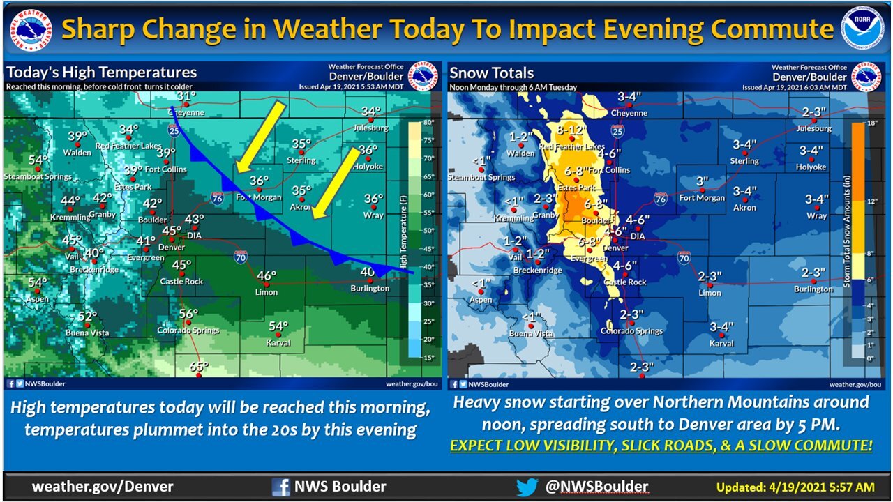
How much will we get?
Now that's a loaded question. But the forecast models — so far — are showing a heavy shot of snow, with 4-6 inches expected in Denver and along the Interstate 25 corridor. Snowfall amounts should be higher into the foothills and northern mountains, in the Estes Park area, with 6-8 inches expected throughout that area.
This will be a relatively quick storm, about 12 hours from start to finish, according to the National Weather Service. But with 4-6 inches of snow falling in that time frame — and higher amounts to the west of Denver — expect to see heavy snowfall rates through the evening.
The NWS on Monday morning was projecting about an inch of water in the snowfall for the mountains and foothills areas, with half an inch to 8/10 of an inch of water for the Denver area.
Here are the latest snowfall projections, via the NWS:

What's next?
The snow should clear out of the area by Tuesday morning, though temperatures will be in the 20s and teens across northern Colorado. We could see some light showers throughout the week, but the weather is expected to dry out and warm up for the weekend.
