


A Flash Flood Watch will go into effect for much of the western half of Colorado starting at noon Monday.
The National Weather Service out of Boulder published the below map of the watch area on Monday morning. A Flash Flood Watch means that conditions will be favorable for flash flooding, but is not currently happening. When flooding is imminent or occurring, the alert is upgraded to a Flash Flood Warning.

A Flash Flood Warning is currently in place for the Purgatoire River near Las Animas in Bent County. This includes Madrid, Trinidad Lake and Trinidad. Minor flooding is possible, the NWS said. The warning ends Wednesday morning.
Before the storms move in this afternoon, smoke will continue to hang in the air, especially around the eastern plains. The smoke is from fires in the northwest United States and Canada. Much of the eastern half of the state is under an Air Quality Alert.
The Air Quality Alert for Douglas, Jefferson, Denver, western Arapahoe, western Adams, Broomfield, Boulder, Larimer, and Weld Counties will end at 4 p.m. Monday.
Many counties will stay under the alert until 9 a.m. Tuesday, including:
- Teller County
- El Paso County
- Morgan County
- Logan County
- Sedgwick County
- Phillips County
- Washington County
- Yuma County
- Lincoln County
- Kit Carson County
- Cheyenne County
- Crowley County
- Kiowa County
- Otero County
- Bent County
- Prowers County
- Baca County
- Las Animas County
- Elbert County
- Pueblo County
- Huerfano County
By the afternoon, the chance of thunderstorms increases in higher terrain areas.
These slow-moving storms will increase the risk of flash flooding over Colorado's burn scars, particularly at the areas of the Williams Fork, Cameron Peak and East Troublesome wildfires.
Flash flood potential increases today, especially for the East Troublesome, Williams Fork, and Cameron Peak burn areas. Slow moving thunderstorms are possible after about 12PM today. #cowx pic.twitter.com/f9jUyDUDIc
— NWS Boulder (@NWSBoulder) August 2, 2021
This monsoonal moisture is expected to primarily hit the north central mountains west of the Continental Divide, NWS reported.
The NWS said it's not yet clear how the east side of the divide will be impacted, but the Flash Flood Watch was expanded to South Park and the northern Front Range and foothills.
The risk of flooding is high to moderate west of the Continental Divide. The Colorado Water Conservation Board said up to 3.6 inches of rain may fall Monday on terrain over 8,000 feet in areas of the northern mountains, central mountains, and San Juan Mountains.
#FTB: A HIGH #COflood threat has been posted for most of high terrain >8k feet where up to 3.6 inches of rain is expected today. A MOD/LOW threat has been posted for surrounding areas. Stay tuned to @NWSBoulder, @NWSGJT and @NWSPueblo for warnings. #cowxhttps://t.co/SFo4lmrPRB pic.twitter.com/7jU3GvAkvE
— CO Flood Updates (@COFloodUpdates) August 2, 2021
A moderate flood threat is in effect for parts of the northwest slope, Grand Valley, southwest slope, southeast mountains and Front Range.
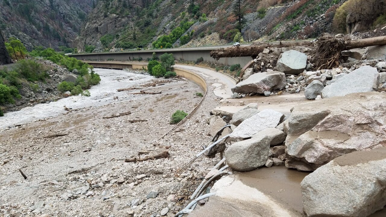
Interstate 70 through Glenwood Springs remains closed after this weekend's storms.
Officials said they found “extreme damage” to the highway.
It's not known when it will reopen or how this week's storms will impact cleanup efforts.
(8/1) I-70 through Glenwood Canyon will continue to be closed due to extreme damage from the latest round of flooding Saturday night (7/31). Motorists advised to take northern alternate route (see map), and trucks traveling through take I-80. Go to https://t.co/bjBVfjLWOG. pic.twitter.com/LOJIV0rvh6
— Colorado Department of Transportation (CDOT) (@ColoradoDOT) August 1, 2021
Tuesday and Wednesday will bring some more storms and showers to the Front Range.
Later in the week, conditions will dry out and heat up again.
