


Click here for a live blog of Thursday and Friday's snowstorm.
As the mountains continue to see increases in snow accumulation and avalanche danger this week, Denverites are preparing for a snowstorm that could bring a few inches around the city along with a sharp dip in temperature.
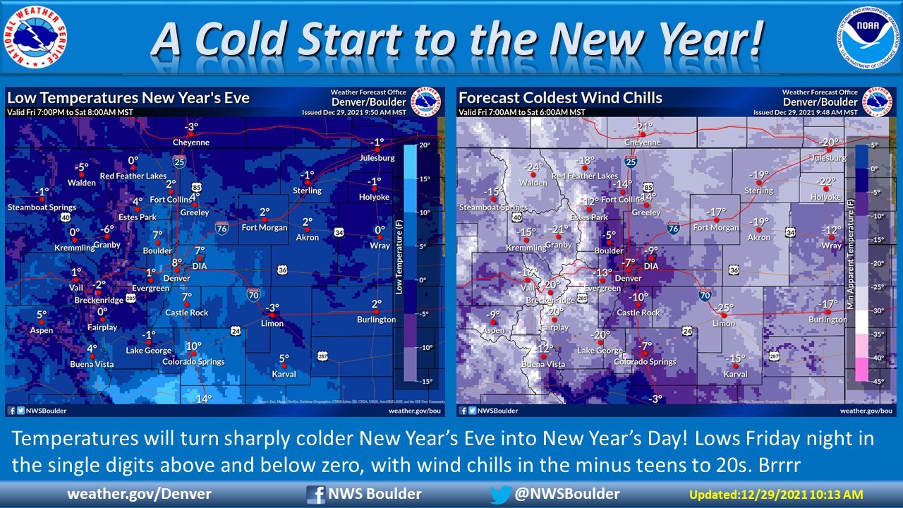
According to the National Weather Service out of Boulder, lows will dip into the single-digits on the evening of New Year's Eve: Denver is forecasted for 8 degrees, Boulder for 7 degrees, Evergreen for 1 degree and Castle Rock for 7 degrees. Wind chills plummet the metro area into the negatives.
Denver will see a brief warm-up Thursday with highs in the 50s before a colder day Friday, where temperatures will only reach the high 30s ahead of the snow. Saturday's highs will stay in the low 20s, according to the NWS.
Meanwhile, the mountains are under a slew of snow-related weather alerts.
A Winter Storm Watch will go into effect on Wednesday at 11 p.m. and will last through 5 a.m. on Saturday for Colorado's northern and central mountains. Visibility in these areas may be slim to none with white-out conditions due to blowing and drifting snow. This will likely make traffic very difficult, especially at higher elevations.
In addition to the Winter Storm Watch, a High Wind Watch will go into effect starting Thursday at 5 a.m. through 11 p.m. in the northern mountains and northern foothills. These winds could become a hazard for drivers in lightweight or high-profile vehicles.

Gusts are expected to stay the strongest along the Continental Divide, where they could reach speeds of 75 mph in the northern mountains and foothills.
In Denver, the wind will remain gusty, but not to that extent — we'll likely see about 33 mph in Denver, and 40 mph in Boulder and Castle Rock.
Across the state through New Year's Eve, snowfall will mostly range from about a foot to a few inches. However, a few high-elevation spots will see 1 to 3 feet of additional snowfall, according to the Colorado Avalanche Information Center (CAIC).

Given the conditions, CAIC issued avalanche watches for the Steamboat and Flat Tops, Aspen, Gunnison, Grand Mesa, and South San Juan zones. These watches went into effect Wednesday morning and will be lifted on Thursday at 8 a.m. Avalanche danger is high — level 4 of 5 — in these areas due to the incoming snowfall and strong wind.
The Front Range, Vail and Summit County, Sawatch and North San Juan zones are under a considerable threat, which is level 3 of 5, according to CAIC.
The CAIC said the next peak for avalanche danger will line up with the new year's holiday.
Ethan Greene, director of CAIC, said the group just saw proof of the avalanche danger in the backcountry over the Christmas weekend.
"We recorded over 200 avalanches in a three-day period. Eight people were buried in avalanches, and one backcountry skier was killed," he said. “Avalanches are getting bigger; you can trigger them from adjacent flat slopes. They are breaking much wider than people expect.”
Some are breaking half a mile wide, CAIC said, and adventurers are triggering avalanches on low-angle slopes.
Avalanche danger will rise Thursday and Friday, CAIC said.
Click here to review the current avalanche forecast for Colorado.
